Geolocate

Ash Lake topographic map

Click on the map to display elevation.

About this map

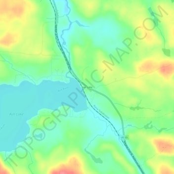
Name: Ash Lake topographic map, elevation, terrain.

Location: Ash Lake, Saint Louis County, Minnesota, United States (48.19880 -92.93600 48.23880 -92.89600)

Average elevation: 413 m

Minimum elevation: 386 m

Maximum elevation: 456 m

Other topographic maps

Click on a map to view its topography, its elevation and its terrain.

Babbitt

United States > Minnesota > Saint Louis County

Average elevation: 484 m

Mug Lake

United States > Minnesota > Saint Louis County

Average elevation: 375 m

Gear up for your next adventure:

🧣Merino Neck Gaiter - Protects against wind, sun, and cold at high altitudes
🧥Ultralight Puffy Jacket - Maximum warmth that packs down to the size of an orange
🧊Insulated Water Bottle - Keeps drinks cold in summer and prevents freezing in winter
📷Outdoor Action Camera - Capture high-elevation views and rugged adventures
🔦UV Flashlight - Detect minerals or specific insects in the dark

As an Amazon Associate, this site earns from qualifying purchases at no extra cost to you.