
Make a donation
Gear up for your next adventure:
As an Amazon Associate, this site earns from qualifying purchases at no extra cost to you.
Zahmer Kaiser topographic map
Click on the map to display elevation.
Make a donation
Gear up for your next adventure:
As an Amazon Associate, this site earns from qualifying purchases at no extra cost to you.
Zahmer Kaiser
The Kaiser Mountains are divided into the Wilder Kaiser or Wild Kaiser chain of mountains, formed predominantly of bare limestone rock, and the Zahmer Kaiser ("Tame Kaiser"), whose southern side is mainly covered by mountain pine. These two mountain ridges are linked by the 1,580-metre-high Stripsenjoch pass, but are separated in the west by the valley of Kaisertal and in the east by the Kaiserbach valley. In total the Kaiser extends for about 20 km (12 mi) in an east-west direction and about 14 km (8.7 mi) from north to south, giving a total area of some 280 square kilometres (110 sq mi). The Zahmer Kaiser only just breaks through the 2,000 metre barrier (in the Vordere Kesselschneid). The highest elevation in the Wilder Kaiser is the Ellmauer Halt in the borough of Kufstein at 2,344 metres (7,690 ft). There are around forty other summits, including many well-known climbing peaks such as the Karlspitzen, Totenkirchl, Fleischbank, Predigtstuhl, Goinger Halt, Ackerlspitze and Maukspitze.
Make a donation
Gear up for your next adventure:
As an Amazon Associate, this site earns from qualifying purchases at no extra cost to you.
About this map
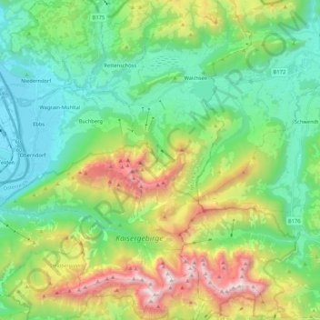
Name: Zahmer Kaiser topographic map, elevation, terrain.
Location: Zahmer Kaiser, Bezirk Kufstein, Tyrol, 6341, Austria (47.57607 12.17763 47.65363 12.38776)
Average elevation: 1,020 m
Minimum elevation: 461 m
Maximum elevation: 2,301 m
Make a donation
Gear up for your next adventure:
As an Amazon Associate, this site earns from qualifying purchases at no extra cost to you.
Other topographic maps
Click on a map to view its topography, its elevation and its terrain.
Make a donation
Gear up for your next adventure:
As an Amazon Associate, this site earns from qualifying purchases at no extra cost to you.
Make a donation
Gear up for your next adventure:
As an Amazon Associate, this site earns from qualifying purchases at no extra cost to you.
Make a donation
Gear up for your next adventure:
As an Amazon Associate, this site earns from qualifying purchases at no extra cost to you.
Make a donation
Gear up for your next adventure:
As an Amazon Associate, this site earns from qualifying purchases at no extra cost to you.
Hoher Burgstall
Austria > Tyrol > Bezirk Innsbruck-Land > Neustift im Stubaital
Average elevation: 2,142 m
Make a donation
Gear up for your next adventure:
As an Amazon Associate, this site earns from qualifying purchases at no extra cost to you.
Make a donation
Gear up for your next adventure:
As an Amazon Associate, this site earns from qualifying purchases at no extra cost to you.
Make a donation
Gear up for your next adventure:
As an Amazon Associate, this site earns from qualifying purchases at no extra cost to you.
Make a donation
Gear up for your next adventure:
As an Amazon Associate, this site earns from qualifying purchases at no extra cost to you.
Make a donation
Gear up for your next adventure:
As an Amazon Associate, this site earns from qualifying purchases at no extra cost to you.
Make a donation
Gear up for your next adventure:
As an Amazon Associate, this site earns from qualifying purchases at no extra cost to you.
Make a donation
Gear up for your next adventure:
As an Amazon Associate, this site earns from qualifying purchases at no extra cost to you.
Make a donation
Gear up for your next adventure:
As an Amazon Associate, this site earns from qualifying purchases at no extra cost to you.
Elferspitze
Austria > Tyrol > Bezirk Innsbruck-Land > Neustift im Stubaital
Average elevation: 1,978 m
Make a donation
Gear up for your next adventure:
As an Amazon Associate, this site earns from qualifying purchases at no extra cost to you.
Make a donation
Gear up for your next adventure:
As an Amazon Associate, this site earns from qualifying purchases at no extra cost to you.
Make a donation
Gear up for your next adventure:
As an Amazon Associate, this site earns from qualifying purchases at no extra cost to you.
Make a donation
Gear up for your next adventure:
As an Amazon Associate, this site earns from qualifying purchases at no extra cost to you.
Make a donation
Gear up for your next adventure:
As an Amazon Associate, this site earns from qualifying purchases at no extra cost to you.
Oberlängenfeld
Austria > Tyrol > Bezirk Imst > Gemeinde Längenfeld > Längenfeld
Average elevation: 1,584 m
Make a donation
Gear up for your next adventure:
As an Amazon Associate, this site earns from qualifying purchases at no extra cost to you.
Make a donation
Gear up for your next adventure:
As an Amazon Associate, this site earns from qualifying purchases at no extra cost to you.
Make a donation
Gear up for your next adventure:
As an Amazon Associate, this site earns from qualifying purchases at no extra cost to you.
Unterlängenfeld
Austria > Tyrol > Bezirk Imst > Gemeinde Längenfeld > Längenfeld
Average elevation: 1,590 m
Make a donation
Gear up for your next adventure:
As an Amazon Associate, this site earns from qualifying purchases at no extra cost to you.
Axamer Lizum
Austria > Tyrol > Bezirk Innsbruck-Land > Gemeinde Axams > Axamer Lizum
Average elevation: 1,858 m
Pettneu am Arlberg
Austria > Tyrol > Bezirk Landeck > Gemeinde Pettneu am Arlberg > Pettneu am Arlberg
Average elevation: 1,614 m
Make a donation
Gear up for your next adventure:
As an Amazon Associate, this site earns from qualifying purchases at no extra cost to you.
Make a donation
Gear up for your next adventure:
As an Amazon Associate, this site earns from qualifying purchases at no extra cost to you.
Salzbodensee
Austria > Tyrol > Bezirk Lienz > Marktgemeinde Matrei in Osttirol
Average elevation: 2,250 m
Make a donation
Gear up for your next adventure:
As an Amazon Associate, this site earns from qualifying purchases at no extra cost to you.
Bobojach
Austria > Tyrol > Bezirk Lienz > Gemeinde Prägraten am Großvenediger
Average elevation: 1,728 m