Geolocate

Klamm topographic map

Click on the map to display elevation.

About this map

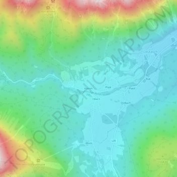
Name: Klamm topographic map, elevation, terrain.

Location: Klamm, Leutasch, Bezirk Innsbruck-Land, Tyrol, 6105, Austria (47.34196 11.10172 47.38196 11.14172)

Average elevation: 1,366 m

Minimum elevation: 1,121 m

Maximum elevation: 2,070 m

Other topographic maps

Click on a map to view its topography, its elevation and its terrain.

Gaistal

Austria > Tyrol > Bezirk Innsbruck-Land > Leutasch

Average elevation: 1,731 m

Gear up for your next adventure:

🕯️Camping Lantern - Illuminates your entire campsite with high-efficiency LEDs
Bushcraft Tarp - Versatile emergency shelter or gear protection
🦟Insect Repellent - Keep mosquitoes and black flies away in wooded areas
💧Filtered Water Bottle - Safe drinking water on the go
🔥Camping Stove - Portable stoves to cook outdoors with ease

As an Amazon Associate, this site earns from qualifying purchases at no extra cost to you.