
Clay County topographic map
Click on the map to display elevation.
Clay County
According to the U.S. Census Bureau, the county has a total area of 644 square miles (1,670 km2), of which 604 square miles (1,560 km2) are land and 39 square miles (100 km2) (6.1%) are covered by water. The average elevation in Clay County is 95 feet above sea level with the highest point, located on the western border in Camp Blanding, being 259 feet. The southwestern portion of the county features many lakes which contribute to the Floridan Aquifer and are an important source of water for the surrounding region. During the 2000s, high growth rates in Northeast Florida caused many of the lakes to dry up as demand for water increased. To combat this, a project began in August 2022 to construct a pipeline from Black Creek in the central part of the county to Alligator Creek in Keystone Heights. This pipeline is expected to restore the water levels in the lakes to their former high points.
About this map
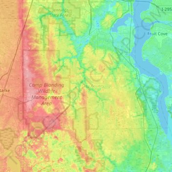
Name: Clay County topographic map, elevation, terrain.
Location: Clay County, Florida, United States (29.71843 -82.04942 30.19347 -81.58121)
Average elevation: 29 m
Minimum elevation: -2 m
Maximum elevation: 79 m
Other topographic maps
Click on a map to view its topography, its elevation and its terrain.
Jacksonville
United States > Florida > Duval County > Jacksonville
Just south of Jacksonville and north of Saint Augustine is the boundary of where the Floridian Peninsula ends and Continental North America begins; Jacksonville is north of that line. While still in the North American Coastal plain, the topography begins to take on slight Piedmont characteristics. Like the…
Average elevation: 9 m
Lealman
United States > Florida > Pinellas County
Lealman is located at 27°49′10″N 82°41′4″W / 27.81944°N 82.68444°W / 27.81944; -82.68444 (27.8197, -82.6846). The community is bordered by the city of Pinellas Park to the north, St. Petersburg to the east and south, and by the town of West Lealman to the west. The elevation is 49 feet (15…
Average elevation: 13 m
Deerfield Beach Century Village
United States > Florida > Broward County > Deerfield Beach
Average elevation: 8 m
Miami
United States > Florida > Miami-Dade County
Miami and its suburbs are located on a broad plain between the Everglades to the west and Biscayne Bay to the east, which extends from Lake Okeechobee southward to Florida Bay. The elevation of the area averages at around 6 ft (1.8 m) above sea level in most neighborhoods, especially near the coast. The…
Average elevation: 4 m
Ave Maria
United States > Florida > Collier County
Ave Maria is 36 miles northeast of downtown Naples, Florida, and part of Collier County. The town's elevation is 18 feet. According to the United States Census Bureau, the city has a total area of 10.424sq mi (27.01km2).
Average elevation: 8 m
West Samoset
United States > Florida > Manatee County > South Bradenton > West Samoset
Average elevation: 11 m
Deering Innovation Park
United States > Florida > Volusia County > New Smyrna Beach
Average elevation: 8 m
Highland Woods Golf & Country Club
United States > Florida > Lee County > Bonita Springs
Average elevation: 5 m
South Sister Island
United States > Florida > Indian River County > Indian River Shores
Average elevation: 4 m