Geolocate

Deltona topographic map

Click on the map to display elevation.

About this map

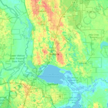
Name: Deltona topographic map, elevation, terrain.

Location: Deltona, Volusia County, Florida, 32725, United States (28.74054 -81.42367 29.06054 -81.10367)

Average elevation: 12 m

Minimum elevation: -3 m

Maximum elevation: 37 m

Gear up for your next adventure:

💧Hydration Pack - Hands-free hydration system for long hikes
🥾Waterproof Hiking Boots - Essential footwear for rugged terrain and wet Canadian trails
🎒Backpack Rain Cover - External shield to keep your entire pack dry
💡Compact LED Flashlight - Powerful and portable flashlight for outdoor use
🚲Bike Repair Kit - Essential tools for on-trail mechanical issues

As an Amazon Associate, this site earns from qualifying purchases at no extra cost to you.