Geolocate

Whitney topographic map

Click on the map to display elevation.

About this map

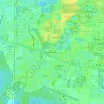
Name: Whitney topographic map, elevation, terrain.

Location: Whitney, Lake County, Florida, 34738, United States (28.79721 -81.95703 28.83721 -81.91703)

Average elevation: 25 m

Minimum elevation: 14 m

Maximum elevation: 41 m

Other topographic maps

Click on a map to view its topography, its elevation and its terrain.

Jacks Lake

United States > Florida > Lake County > Clermont

Average elevation: 54 m

Eustis

United States > Florida > Lake County

Average elevation: 28 m

Erie Lake

United States > Florida > Lake County

Average elevation: 34 m

Mount Plymouth

United States > Florida > Lake County

Average elevation: 25 m

Tavares

United States > Florida > Lake County > Tavares

Average elevation: 22 m

Lake Louisa

United States > Florida > Lake County

Average elevation: 31 m

Gear up for your next adventure:

🦯Trekking Poles - Reduced impact on joints for steep topographic climbs
🔋Solar Power Bank - Keep your GPS and devices charged during long outdoor trips
❄️Traction Ice Cleats - Slip-on spikes for icy trails and winter hiking
🧭Orienteering Kit - Tools for map reading and navigation in the wild
🧭GPS Tracker - Track your location in remote areas safely

As an Amazon Associate, this site earns from qualifying purchases at no extra cost to you.