Geolocate

Fort Walsh topographic map

Click on the map to display elevation.

About this map

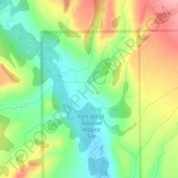
Name: Fort Walsh topographic map, elevation, terrain.

Location: Fort Walsh, Maple Creek No. 111, Division No. 4, Saskatchewan, Canada (49.56314 -109.88912 49.58314 -109.86912)

Average elevation: 1,161 m

Minimum elevation: 1,101 m

Maximum elevation: 1,244 m

Maple Creek No. 111 trails, hiking, mountain biking, running and outdoor activities

Other topographic maps

Click on a map to view its topography, its elevation and its terrain.

Loch Leven

Canada > Saskatchewan > Maple Creek No. 111

Average elevation: 1,227 m

Gear up for your next adventure:

🎒Hiking Backpack - Lightweight and ergonomic backpacks for day hikes or multi-day treks
🛏️Sleeping Bag - Warm and compact sleeping bags for outdoor camping
Camping Coffee Maker - Brew fresh coffee anywhere on the topographic map
Lightweight Camping Tent - Portable shelter optimized for Canadian backcountry camping
🪜Heavy Duty Carabiners - Multi-use clips for securing gear to your backpack

As an Amazon Associate, this site earns from qualifying purchases at no extra cost to you.