
Southland District topographic map
Interactive map
Click on the map to display elevation.
About this map
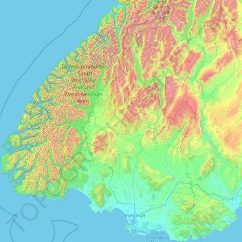
Name: Southland District topographic map, elevation, terrain.
Location: Southland District, Southland, New Zealand (-47.29000 166.42555 -44.25512 169.27947)
Average elevation: 317 m
Minimum elevation: -2 m
Maximum elevation: 2,681 m
Other topographic maps
Click on a map to view its topography, its elevation and its terrain.
Reserve
New Zealand > Northland > Far North District > Bay of Islands-Whangaroa Community > Kerikeri
Reserve, Blue Marlin Estate, Kerikeri, Bay of Islands-Whangaroa Community, Far North District, Northland, New Zealand
Average elevation: 56 m
Tongariro National Park
New Zealand > Manawatu-Whanganui > Ruapehu District
Tongariro National Park, Ruapehu District, Manawatū-Whanganui, New Zealand
Average elevation: 888 m
Hibiscus and Bays
Hibiscus and Bays, Auckland, New Zealand
Average elevation: 20 m
Timaru District
Timaru District, Canterbury, New Zealand
Average elevation: 560 m
Palmerston North
New Zealand > Manawatu-Whanganui
Palmerston North, Manawatū-Whanganui, New Zealand
Average elevation: 133 m
Scotsman Valley
New Zealand > Waikato > Waikato District
Scotsman Valley, Waikato District, Waikato, New Zealand
Average elevation: 108 m
Levin
New Zealand > Manawatu-Whanganui > Horowhenua District
Levin, Horowhenua District, Manawatū-Whanganui, 5510, New Zealand
Average elevation: 41 m
Taumatawhakatangihangakōauauotamateapōkaiwhenuakitānatahu
New Zealand > Hawke's Bay > Central Hawke's Bay District
Taumatawhakatangihangakōauauotamateapōkaiwhenuakitānatahu, Central Hawke's Bay District, Hawke's Bay, New Zealand
Average elevation: 199 m
Cape Kidnappers / Te Kauwae-a-Māui
New Zealand > Hawke's Bay > Hastings District
Cape Kidnappers / Te Kauwae-a-Māui, Hastings District, Hawke's Bay, New Zealand
Average elevation: 16 m
Wentworth Valley
New Zealand > Waikato > Thames-Coromandel District
Wentworth Valley, Thames-Coromandel District, Waikato, New Zealand
Average elevation: 114 m
Point Erin
New Zealand > Auckland > Auckland
Point Erin, Saint Marys Bay, Auckland, Waitematā, Auckland, 1011, New Zealand
Average elevation: 9 m
Ice Lake
New Zealand > West Coast > Westland District
Ice Lake, Westland District, West Coast, New Zealand
Average elevation: 1,343 m
Waitara
New Zealand > Taranaki > New Plymouth District
Waitara, New Plymouth District, Taranaki, 4320, New Zealand
Average elevation: 28 m
Upper Hutt
New Zealand > Wellington > Upper Hutt City
Upper Hutt, Upper Hutt City, Wellington, 5218, New Zealand
Average elevation: 271 m
Blake
New Zealand > Wellington > Masterton District
Blake, Masterton District, Wellington, New Zealand
Average elevation: 568 m
Eureka
New Zealand > Waikato > Waikato District
Eureka, Waikato District, Waikato, 3287, New Zealand
Average elevation: 49 m
Wānaka
New Zealand > Otago > Queenstown-Lakes District
Wānaka, Queenstown-Lakes District, Otago, 9305, New Zealand
Average elevation: 381 m
Alexandra
New Zealand > Otago > Central Otago District > Vincent Community
Alexandra, Vincent Community, Central Otago District, Otago, 9320, New Zealand
Average elevation: 241 m
Cardrona
New Zealand > Otago > Queenstown-Lakes District
Cardrona, Queenstown-Lakes District, Otago, New Zealand
Average elevation: 758 m
Orepuki
New Zealand > Southland > Southland District > Tuatapere Te Waewae Community
Orepuki, Tuatapere Te Waewae Community, Southland District, Southland, New Zealand
Average elevation: 22 m
Patata
New Zealand > Manawatu-Whanganui > Ruapehu District
Patata, Ruapehu District, Manawatū-Whanganui, 3990, New Zealand
Average elevation: 356 m
Waikari River
New Zealand > Canterbury > Hurunui District
Waikari River, Hurunui District, Canterbury, New Zealand
Average elevation: 232 m
Selwyn
New Zealand > Canterbury > Selwyn District
Selwyn, Selwyn District, Canterbury, 7682, New Zealand
Average elevation: 70 m
Ohingaora
New Zealand > Hawke's Bay > Napier
Ohingaora, Napier, Hawke's Bay, 4141, New Zealand
Average elevation: 23 m
Duntroon
New Zealand > Canterbury > Waitaki District
Duntroon, Waitaki District, Canterbury, New Zealand
Average elevation: 150 m
Folgers Hill
New Zealand > Hawke's Bay > Central Hawke's Bay District
Folgers Hill, Central Hawke's Bay District, Hawke's Bay, New Zealand
Average elevation: 519 m
Prince of Wales
New Zealand > Otago > Queenstown-Lakes District
Prince of Wales, Queenstown-Lakes District, Otago, New Zealand
Average elevation: 1,274 m
Mt Baldy
New Zealand > West Coast > Buller District
Mt Baldy, Buller District, West Coast, New Zealand
Average elevation: 1,059 m
Wellington
New Zealand > Wellington > Wellington City
Wellington, Wellington City, Wellington, 6011, New Zealand
Average elevation: 85 m
Lake William
New Zealand > Manawatu-Whanganui > Rangitīkei District
Lake William, Rangitīkei District, Manawatū-Whanganui, New Zealand
Average elevation: 100 m
North Shore
New Zealand > Auckland > Kaipātiki
North Shore, Totara Vale, Kaipātiki, Auckland, 0629, New Zealand
Average elevation: 57 m
Halswell-Hornby-Riccarton Community
New Zealand > Canterbury > Christchurch City
Halswell-Hornby-Riccarton Community, Christchurch City, Canterbury, New Zealand
Average elevation: 49 m
Barometer
Barometer, Marlborough, 7240, New Zealand
Average elevation: 1,397 m
McKerrow
New Zealand > Wellington > Lower Hutt City
McKerrow, Lower Hutt City, Wellington, New Zealand
Average elevation: 441 m
Crown Island
Crown Island, Akaroa, Canterbury, New Zealand
Average elevation: 69 m