Geolocate

Timaru District topographic map

Click on the map to display elevation.

About this map

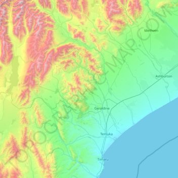
Name: Timaru District topographic map, elevation, terrain.

Location: Timaru District, Canterbury, New Zealand (-44.50102 170.58229 -43.45148 171.50745)

Average elevation: 560 m

Minimum elevation: 0 m

Maximum elevation: 2,750 m

Other topographic maps

Click on a map to view its topography, its elevation and its terrain.

Geraldine

New Zealand > Canterbury > Timaru District

Average elevation: 130 m

Selwyn

New Zealand > Canterbury > Selwyn District

Average elevation: 70 m

Duntroon

New Zealand > Canterbury > Waitaki District

Average elevation: 150 m

Smite Peak

New Zealand > Canterbury > Ashburton District

Average elevation: 1,595 m

Crown Island

New Zealand > Canterbury

Average elevation: 69 m

Gear up for your next adventure:

🔦LED Flashlight - Powerful and long-lasting flashlight for camping and emergencies
🥾Trail Running Boots - Durable shoes designed for trail running
🧴Sunscreen SPF - Broad-spectrum sunscreen for outdoor activities
🚲Bike Repair Kit - Essential tools for on-trail mechanical issues
🥾Trail Hiking Shoes - Durable shoes designed for rugged trails

As an Amazon Associate, this site earns from qualifying purchases at no extra cost to you.