Geolocate

Kaikōura topographic map

Interactive map

Click on the map to display elevation.

About this map

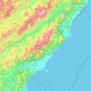
Name: Kaikōura topographic map, elevation, terrain.

Location: Kaikōura, Canterbury, New Zealand (-42.56573 173.18065 -41.90740 174.06338)

Average elevation: 530 m

Minimum elevation: 0 m

Maximum elevation: 2,849 m

The Hutton's shearwater (Puffinus huttoni) or Kaikōura tītī is an endangered seabird in the family Procellariidae. It is found in waters around Australia and New Zealand but it only breeds in the Seaward Kaikōura Range in New Zealand. It is the only seabird in the world that breeds in an alpine environment. Nests have been found at elevations from 1200 to 1800 metres. The Kowhai Valley and Shearwater Stream Important Bird Area contains the only two remaining alpine breeding colonies. An artificial colony was established in a protected area on the Kaikōura peninsula as a conservation measure, after six other colonies were wiped out by feral pigs. The birds fly at night, but can become disoriented by bright lights. Fledglings are particularly vulnerable, and can crash-land on roads in the town. They are usually unable to take off again, making them vulnerable to being run over by vehicles or succumbing to predation by dogs or cats. Conservation organizations in Kaikōura rescue stranded birds for later release, and advocate for reduced lighting.

Wikipedia (CC-BY-SA 3.0)

Other topographic maps

Click on a map to view its topography, its elevation and its terrain.

Timaru District

New Zealand > Canterbury

Timaru District, Canterbury, New Zealand

Average elevation: 560 m

Waikari River

New Zealand > Canterbury > Hurunui District

Waikari River, Hurunui District, Canterbury, New Zealand

Average elevation: 232 m

Selwyn

New Zealand > Canterbury > Selwyn District

Selwyn, Selwyn District, Canterbury, 7682, New Zealand

Average elevation: 70 m

Duntroon

New Zealand > Canterbury > Waitaki District

Duntroon, Waitaki District, Canterbury, New Zealand

Average elevation: 150 m

Halswell-Hornby-Riccarton Community

New Zealand > Canterbury > Christchurch City

Halswell-Hornby-Riccarton Community, Christchurch City, Canterbury, New Zealand

Average elevation: 49 m

Crown Island

New Zealand > Canterbury

Crown Island, Akaroa, Canterbury, New Zealand

Average elevation: 69 m

Smite Peak

New Zealand > Canterbury > Ashburton District

Smite Peak, Ashburton District, Canterbury, New Zealand

Average elevation: 1,595 m

Victoria Clock Tower

New Zealand > Canterbury > Christchurch City > Linwood-Central-Heathcote Community

Victoria Clock Tower, Victoria Street, Central City, Linwood-Central-Heathcote Community, Christchurch City, Canterbury, 8011, New Zealand

Average elevation: 11 m

Kiosk Lake

New Zealand > Canterbury > Christchurch City > Christchurch

Kiosk Lake, Central City, Christchurch, Christchurch City, Canterbury, New Zealand

Average elevation: 12 m

Lake McGregor

New Zealand > Canterbury > Mackenzie District

Lake McGregor, Mackenzie District, Canterbury, New Zealand

Average elevation: 738 m

Rangiora

New Zealand > Canterbury > Waimakariri District > Rangiora

Rangiora, Waimakariri District, Canterbury, 7400, New Zealand

Average elevation: 31 m

Lake Clearwater

New Zealand > Canterbury > Lake Clearwater

Lake Clearwater, Ashburton District, Canterbury, New Zealand

Average elevation: 751 m

Hanmer Springs

New Zealand > Canterbury > Hanmer Springs

Hanmer Springs, Hurunui District, Canterbury, 7334, New Zealand

Average elevation: 397 m

Canterbury

New Zealand > Canterbury

Canterbury, New Zealand

Average elevation: 357 m

Christchurch

New Zealand > Canterbury > Christchurch City

Christchurch, Christchurch City, Canterbury, New Zealand

Average elevation: 41 m

Lawrence River

New Zealand > Canterbury

Lawrence River, Ashburton District, Canterbury, New Zealand

Average elevation: 1,495 m

Cascade Glacier

New Zealand > Canterbury

Cascade Glacier, Mackenzie District, Canterbury, New Zealand

Average elevation: 2,106 m

Grey River

New Zealand > Canterbury

Grey River, Hurunui District, Canterbury, New Zealand

Average elevation: 439 m

Mount Vancouver

New Zealand > Canterbury

Mount Vancouver, Mackenzie District, Canterbury, New Zealand

Average elevation: 2,804 m

Godley Glacier

New Zealand > Canterbury

Godley Glacier, Mackenzie District, Canterbury, New Zealand

Average elevation: 1,802 m

Ball Glacier

New Zealand > Canterbury

Ball Glacier, Caroline hut to ball hut, Mackenzie District, Canterbury, New Zealand

Average elevation: 1,324 m

Maud Glacier

New Zealand > Canterbury

Maud Glacier, Mackenzie District, Canterbury, New Zealand

Average elevation: 1,711 m

Dennistoun Glacier

New Zealand > Canterbury

Dennistoun Glacier, Mackenzie District, Canterbury, New Zealand

Average elevation: 2,026 m

Mount Cook

New Zealand > Canterbury > Mackenzie District

Mount Cook, Mackenzie District, Canterbury, New Zealand

Average elevation: 2,920 m

Te Hīwai / Murchison Glacier

New Zealand > Canterbury

Te Hīwai / Murchison Glacier, Mackenzie District, Canterbury, New Zealand

Average elevation: 1,875 m

Mackenzie District

New Zealand > Canterbury

Mackenzie District, Canterbury, New Zealand

Average elevation: 961 m

Mueller Glacier

New Zealand > Canterbury > Mount Cook Village

Mueller Glacier, Mueller Hut Route, Mount Cook Village, Mackenzie District, Canterbury, 7946, New Zealand

Average elevation: 1,616 m

Godley Glacier

New Zealand > Canterbury

Godley Glacier, Mackenzie District, Canterbury, New Zealand

Average elevation: 1,579 m

Burkes Pass

New Zealand > Canterbury > Mackenzie District

Burkes Pass, Mackenzie District, Canterbury, New Zealand

Average elevation: 622 m

Christchurch City

New Zealand > Canterbury

Christchurch City, Canterbury, New Zealand

Average elevation: 74 m

Aida Glacier

New Zealand > Canterbury

Aida Glacier, Mackenzie District, Canterbury, New Zealand

Average elevation: 1,999 m

Gore Bay

New Zealand > Canterbury > Gore Bay

Gore Bay, Hurunui District, Canterbury, New Zealand

Average elevation: 54 m

Eugenie Glacier

New Zealand > Canterbury > Mount Cook Village

Eugenie Glacier, Hooker Valley Track, Mount Cook Village, Mackenzie District, Canterbury, 7946, New Zealand

Average elevation: 1,827 m

Waimakariri District

New Zealand > Canterbury

Waimakariri District, Canterbury, New Zealand

Average elevation: 476 m

Sharks Teeth

New Zealand > Canterbury

Sharks Teeth, Mackenzie District, Canterbury, New Zealand

Average elevation: 1,986 m

South Island

New Zealand > Canterbury

South Island, Ashburton District, Canterbury, New Zealand

Average elevation: 201 m

Anna Glacier

New Zealand > Canterbury

Anna Glacier, Mackenzie District, Canterbury, New Zealand

Average elevation: 2,446 m

Clandeboye

New Zealand > Canterbury > Timaru District > Clandeboye

Clandeboye, Timaru District, Canterbury, New Zealand

Average elevation: 21 m

Mount Dampier

New Zealand > Canterbury

Mount Dampier, Mackenzie District, Canterbury, New Zealand

Average elevation: 2,847 m

Hurunui District

New Zealand > Canterbury

Hurunui District, Canterbury, New Zealand

Average elevation: 674 m