
Osaka Prefecture topographic map
Click on the map to display elevation.
About this map
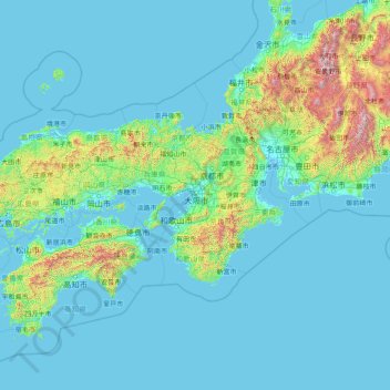
Name: Osaka Prefecture topographic map, elevation, terrain.
Location: Osaka Prefecture, Japan (32.01988 132.89036 37.21988 138.09036)
Average elevation: 188 m
Minimum elevation: -5 m
Maximum elevation: 3,053 m
Other topographic maps
Click on a map to view its topography, its elevation and its terrain.
Funabashi
Funabashi is located in northwestern Chiba Prefecture approximately 20 kilometers in either direction from the prefectural capital at Chiba and downtown Tokyo. The central area forms a flat diluvial upland of the Shimōsa Plateau. The city sits at an elevation of 20 to 30 meters above sea level, and is…
Average elevation: 18 m
Machida
Machida is located in the Tama Hills of southern Tokyo Metropolis, bordered by Kanagawa Prefecture on the west, south, and east approximately 40 to 50 kilometers from the center of Tokyo. The highest point is Mount Kusato (elevation 364 meters) at the western end. There are few flatlands near Machida Station,…
Average elevation: 81 m
Tamba
Tamba is located in an inland basin at an average elevation of 100 meters above sea level in the eastern part of the prefecture. It is located in the mountains between the Seto Inland Sea and the Sea of Japan. The uppermost stream of the Kako River system and the uppermost stream of the Yura River system, flow…
Average elevation: 268 m
Oyama
Oyama is located in the far northeastern corner of Shizuoka Prefecture, bordering on Yamanashi and Kanagawa Prefectures. Located in between the Tanzawa Mountains and the foothills of Mount Fuji, the town has an average altitude of 800 meters, and has a cool climate with heavy rainfall. Some 65% of the town is…
Average elevation: 737 m
Yamanouchi
Shimotakai District, in northern mountainous Nagano Prefecture, comprises Yamanouchi town, Kijimadaira Village, and Nozawaonsen Village. Yamanouchi is the largest of these. More than 90% of Yamanouchi is covered by mountains and forests. The town measures approximately 39 kilometers east-west and 12 kilometers…
Average elevation: 942 m
Okinawa Island
The Motobu Peninsula in the north has limestone layers and karst development. In the center and south is mainly a Ryukyu limestone layer and mudstone. The topography is flat, there are few hills over 100 m (328 ft) with very few rivers. The subtropical rains accelerates erosion so there are many drainages and…
Average elevation: 14 m
Tsukuba
Tsukuba is located in southern Ibaraki Prefecture, approximately 50 kilometers from central Tokyo and about 40 kilometers from Narita International Airport. Mount Tsukuba, from which the city takes its name, is located in the northern part of the city. Except for the area around Mount Tsukuba, the city is a…
Average elevation: 35 m
Narusawa
The city has a climate characterized by characterized by hot and humid summers, and relatively mild winters (Köppen climate classification Cfb). The average annual temperature in Kōshū is 9.6 °C. (Note that the preceding climate information is for a distant location in the same prefecture as Narusawa…
Average elevation: 1,411 m
Kanie
Kanie is located in the southwest Aichi Prefecture in the extreme end of the Nōbi Plain at the delta of the Kiso River, bordering on Ise Bay to the south. The average elevation of the town is sea level.
Average elevation: 0 m
Nozawaonsen
Nozawaonsen is located in mountainous northeastern Nagano Prefecture, about one hour's drive from Nagano City. To the south it borders Kijimadaira along the ridge of Mount Kenashi. To the west side the Chikuma River, the longest river in Japan, which forms a border of the village with the city of Iiyama. The…
Average elevation: 710 m
Fukuchiyama
Fukuchiyama is located in northwestern Kyoto Prefecture, bordering Hyogo Prefecture to the west. It is centered on the Fukuchiyama Basin formed by the Yura River, and is surrounded by mountains to the south, west, and east. It is located about 70 kilometers from downtown Osaka, 60 kilometers from Kyoto or Kobe…
Average elevation: 218 m
Ashiya
A house designed by Frank Lloyd Wright sits on a hill overlooking Hankyu Ashiyagawa Station and Osaka Bay. It was completed in 1924 as a residence for the Yamamura family, founders of the famous sake company "Sakuramasamune" (櫻正宗). It is now known as the Yodokō Guest House and is open for tours. Ashiya…
Average elevation: 118 m
Nagaokakyo
Nagaokakyō is located in southwestern Kyoto Prefecture. The Obata River and Koizumi River flow through the city. The topography is low from the northwest to the southwest. The area is noted for its bamboo forests.
Average elevation: 102 m