Geolocate

Tachikawa topographic map

Click on the map to display elevation.

About this map

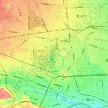
Name: Tachikawa topographic map, elevation, terrain.

Location: Tachikawa, Tokyo, Japan (35.68276 139.35233 35.74514 139.44612)

Average elevation: 97 m

Minimum elevation: 54 m

Maximum elevation: 142 m

Other topographic maps

Click on a map to view its topography, its elevation and its terrain.

Inuyama Castle

Japan > Inuyama

Average elevation: 53 m

4th station

Japan > Miyako

Average elevation: 1,434 m

Hebizuka

Japan > Shibata

Average elevation: 14 m

Osaka Prefecture

Japan

Average elevation: 188 m

Mount Rishiri

Japan > Rishiri County > Rishirifuji

Average elevation: 1,098 m

雀田

Japan > Ogachi County > Ugo

Average elevation: 69 m

Abuta County

Japan > Abuta County

Average elevation: 147 m

Yokohama

Japan > Yokohama

Average elevation: 22 m

Mount Aso

Japan > Aso

With an elevation of 1,143 metres (3,750 ft)., Mount Aso has a climate that falls as humid continental (Köppen climate classification "Dfb"), with warm summers and cold winters. Precipitation is high throughout the year, which brings the area to have borderline subtropical characteristics as well. They are…

Average elevation: 1,203 m

桂木展望台

Japan > Iruma County > Moroyama

Average elevation: 205 m

Gear up for your next adventure:

🔥Emergency Fire Starter - Reliable ignition source for all weather conditions
💧Hydration Bladder - Hands-free hydration solution for long treks
👟Sport Hiking Sandals - Breathable footwear for water crossings and camp rest
🧥Softshell Hiking Jacket - The perfect balance of wind protection and breathability
🧤Insulated Winter Gloves - Heavy-duty protection for sub-zero Canadian adventures

As an Amazon Associate, this site earns from qualifying purchases at no extra cost to you.