Geolocate

Chiba topographic map

Click on the map to display elevation.

About this map

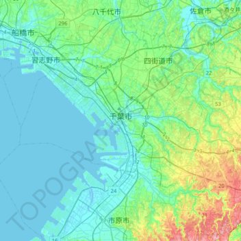
Name: Chiba topographic map, elevation, terrain.

Location: Chiba, Chiba Prefecture, Japan (35.49359 139.98385 35.71461 140.30314)

Average elevation: 21 m

Minimum elevation: -4 m

Maximum elevation: 113 m

Gear up for your next adventure:

🧢Outdoor Cap - Protective cap for sun and rain during hikes
🥾Lightweight Hiking Shoes - Comfortable shoes for day hikes
🔥Camping Stove - Portable stoves to cook outdoors with ease
Backpacking Tent - Lightweight tent for long-distance hiking trips
🥾Trail Running Boots - Durable shoes designed for trail running

As an Amazon Associate, this site earns from qualifying purchases at no extra cost to you.