Geolocate

Oyama topographic map

Click on the map to display elevation.

Oyama

Oyama is located in the far northeastern corner of Shizuoka Prefecture, bordering on Yamanashi and Kanagawa Prefectures. Located in between the Tanzawa Mountains and the foothills of Mount Fuji, the town has an average altitude of 800 meters, and has a cool climate with heavy rainfall. Some 65% of the town is covered in forest.

Wikipedia (CC-BY-SA 3.0)

About this map

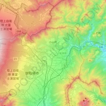
Name: Oyama topographic map, elevation, terrain.

Location: Oyama, Sunto County, Shizuoka Prefecture, Chubu Region, Japan (35.28489 138.73021 35.40518 139.01901)

Average elevation: 737 m

Minimum elevation: 95 m

Maximum elevation: 1,722 m

Gear up for your next adventure:

🎒Hiking Daypack - Lightweight and durable backpacks for day trips and excursions
Camping Tent - Weather-resistant tents suitable for 2 to 6 people
🥾Trail Running Shoes - Lightweight and durable shoes for trail running
💡Compact LED Flashlight - Powerful and portable flashlight for outdoor use
Camping Coffee Maker - Brew fresh coffee anywhere on the topographic map

As an Amazon Associate, this site earns from qualifying purchases at no extra cost to you.