
Tamba topographic map
Click on the map to display elevation.
Tamba
Tamba is located in an inland basin at an average elevation of 100 meters above sea level in the eastern part of the prefecture. It is located in the mountains between the Seto Inland Sea and the Sea of Japan. The uppermost stream of the Kako River system and the uppermost stream of the Yura River system, flow through the city, which has the lowest central watershed in Japan except for Hokkaido. The 35 degree east longitude meridian passes through the city.
About this map
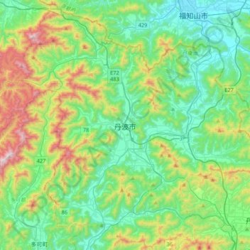
Name: Tamba topographic map, elevation, terrain.
Location: Tamba, Hyogo Prefecture, Japan (35.04675 134.89933 35.30875 135.22864)
Average elevation: 268 m
Minimum elevation: 13 m
Maximum elevation: 969 m
Other topographic maps
Click on a map to view its topography, its elevation and its terrain.
Mount Aso
With an elevation of 1,143 metres (3,750 ft)., Mount Aso has a climate that falls as humid continental (Köppen climate classification "Dfb"), with warm summers and cold winters. Precipitation is high throughout the year, which brings the area to have borderline subtropical characteristics as well. They are…
Average elevation: 1,203 m