Geolocate

Tsu topographic map

Click on the map to display elevation.

About this map

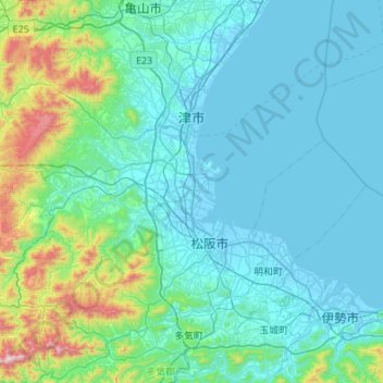
Name: Tsu topographic map, elevation, terrain.

Location: Tsu, Mie Prefecture, Japan (34.44736 136.15973 34.84450 136.70373)

Average elevation: 138 m

Minimum elevation: -5 m

Maximum elevation: 1,057 m

Gear up for your next adventure:

🦯Trekking Poles - Reduced impact on joints for steep topographic climbs
🛌Insulated Sleeping Pad - Critical thermal barrier between you and the cold ground
🥘Camping Cookware Set - Compact nesting pots and pans for trail cooking
🥾Trail Running Shoes - Lightweight and durable shoes for trail running
🥾Trail Hiking Shoes - Durable shoes designed for rugged trails

As an Amazon Associate, this site earns from qualifying purchases at no extra cost to you.