
Machida topographic map
Click on the map to display elevation.
Machida
Machida is located in the Tama Hills of southern Tokyo Metropolis, bordered by Kanagawa Prefecture on the west, south, and east approximately 40 to 50 kilometers from the center of Tokyo. The highest point is Mount Kusato (elevation 364 meters) at the western end. There are few flatlands near Machida Station, the Sakai River flows to the west and south, and the Tsurumi River flows almost in the center of the city.
About this map
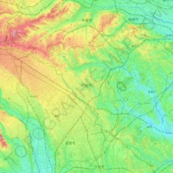
Name: Machida topographic map, elevation, terrain.
Location: Machida, Tokyo, Japan (35.50122 139.26880 35.62350 139.50742)
Average elevation: 81 m
Minimum elevation: 7 m
Maximum elevation: 217 m
Other topographic maps
Click on a map to view its topography, its elevation and its terrain.
Mount Aso
With an elevation of 1,143 metres (3,750 ft)., Mount Aso has a climate that falls as humid continental (Köppen climate classification "Dfb"), with warm summers and cold winters. Precipitation is high throughout the year, which brings the area to have borderline subtropical characteristics as well. They are…
Average elevation: 1,203 m