Geolocate

Nishinomiya topographic map

Click on the map to display elevation.

About this map

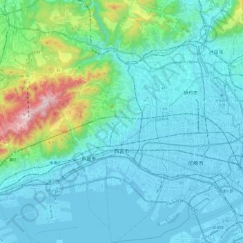
Name: Nishinomiya topographic map, elevation, terrain.

Location: Nishinomiya, Hyogo Prefecture, 662-8567, Japan (34.66326 135.22970 34.86133 135.38432)

Average elevation: 136 m

Minimum elevation: -9 m

Maximum elevation: 916 m

Gear up for your next adventure:

🥾Lightweight Hiking Boots - Boots for comfort and mobility on long hikes
Camping Groundsheet - Protect your tent from moisture and dirt
🎒Backpack Rain Cover - External shield to keep your entire pack dry
🧊Portable Cooler - Keep food and drinks cold during outdoor adventures
💡LED Headlamp - Hands-free illumination for night hiking and camping

As an Amazon Associate, this site earns from qualifying purchases at no extra cost to you.