
Tsukuba topographic map
Click on the map to display elevation.
Tsukuba
Tsukuba is located in southern Ibaraki Prefecture, approximately 50 kilometers from central Tokyo and about 40 kilometers from Narita International Airport. Mount Tsukuba, from which the city takes its name, is located in the northern part of the city. Except for the area around Mount Tsukuba, the city is a part of the Kantō Plain with an altitude of 20 to 30 meters.
About this map
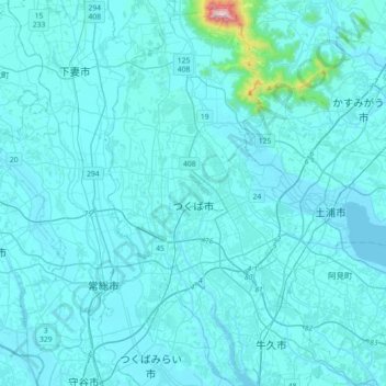
Name: Tsukuba topographic map, elevation, terrain.
Location: Tsukuba, Ibaraki Prefecture, Japan (35.94732 139.99579 36.23683 140.17315)
Average elevation: 35 m
Minimum elevation: 0 m
Maximum elevation: 842 m
Other topographic maps
Click on a map to view its topography, its elevation and its terrain.
Mount Aso
With an elevation of 1,143 metres (3,750 ft)., Mount Aso has a climate that falls as humid continental (Köppen climate classification "Dfb"), with warm summers and cold winters. Precipitation is high throughout the year, which brings the area to have borderline subtropical characteristics as well. They are…
Average elevation: 1,203 m