
Ashford topographic map
Click on the map to display elevation.
About this map
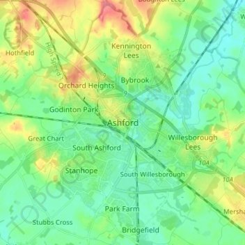
Name: Ashford topographic map, elevation, terrain.
Location: Ashford, Kent, England, TN23 1QL, United Kingdom (51.10856 0.83226 51.18856 0.91226)
Average elevation: 49 m
Minimum elevation: 27 m
Maximum elevation: 99 m
Other topographic maps
Click on a map to view its topography, its elevation and its terrain.
Ramsgate
United Kingdom > England > Kent > Thanet > Pegwell
In 2017 Ramsgate was chosen as one of the first ten Heritage Action Zones (HAZ) by Historic England, with the aim of stimulating economic growth by taking advantage of Ramsgate's historic environment. Part of this project included a Historic Landscape Characterisation Study which assessed and mapped the…
Average elevation: 25 m
Romney, Hythe and Dymchurch Railway
United Kingdom > England > Kent > Folkestone and Hythe > St. Mary in the Marsh
Average elevation: 1 m
Kings Hill
United Kingdom > England > Kent > Tonbridge and Malling > Kings Hill
Average elevation: 82 m