
West Malling topographic map
Click on the map to display elevation.
About this map
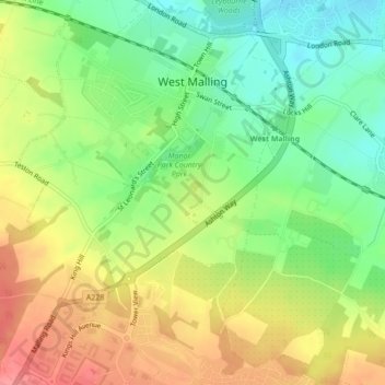
Name: West Malling topographic map, elevation, terrain.
Average elevation: 58 m
Minimum elevation: 20 m
Maximum elevation: 101 m
Other topographic maps
Click on a map to view its topography, its elevation and its terrain.
Ightham Common
United Kingdom > England > Kent > Tonbridge and Malling > Ightham
Average elevation: 145 m
Barden Lake
United Kingdom > England > Kent > Tonbridge and Malling > Tonbridge
Average elevation: 33 m
Kit's Coty
United Kingdom > England > Kent > Tonbridge and Malling > Bluebell Hill
Average elevation: 102 m
Holborough Lakes
United Kingdom > England > Kent > Tonbridge and Malling > Snodland
Average elevation: 32 m
Beltring
United Kingdom > England > Kent > Tonbridge and Malling > East Peckham
Average elevation: 15 m
Pratling Street
United Kingdom > England > Kent > Tonbridge and Malling > Aylesford > Pratling Street
Average elevation: 49 m
Royal British Legion Village
United Kingdom > England > Kent > Tonbridge and Malling
Average elevation: 33 m
Bradbourne
United Kingdom > England > Kent > Tonbridge and Malling > East Malling
Average elevation: 28 m