Geolocate

Plaxtol topographic map

Click on the map to display elevation.

About this map

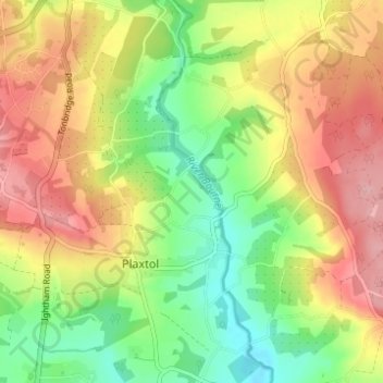
Name: Plaxtol topographic map, elevation, terrain.

Location: Plaxtol, Tonbridge and Malling, Kent, England, United Kingdom (51.24646 0.27757 51.28497 0.33605)

Average elevation: 100 m

Minimum elevation: 36 m

Maximum elevation: 167 m

Gear up for your next adventure:

💡Compact LED Flashlight - Powerful and portable flashlight for outdoor use
🥾Mountain Hiking Shoes - Shoes with superior grip for mountainous terrain
🥾Hiking Gaiters - Protect legs and shoes from mud, snow, and debris
🚲MTB Frame Bag - Carry tools and maps directly on your bicycle frame
🧊Insulated Water Bottle - Keeps drinks cold in summer and prevents freezing in winter

As an Amazon Associate, this site earns from qualifying purchases at no extra cost to you.