Geolocate

Aldington topographic map

Click on the map to display elevation.

About this map

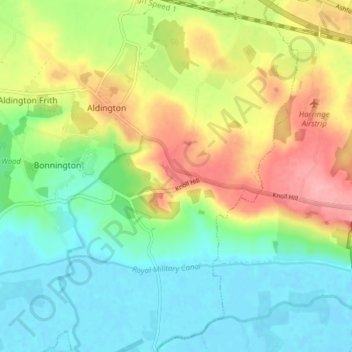
Name: Aldington topographic map, elevation, terrain.

Location: Aldington, Ashford, Kent, England, United Kingdom (51.05826 0.91333 51.10718 0.98538)

Average elevation: 40 m

Minimum elevation: -2 m

Maximum elevation: 107 m

Other topographic maps

Click on a map to view its topography, its elevation and its terrain.

Stonestreet Green

United Kingdom > England > Kent > Ashford > Aldington

Average elevation: 57 m

Gear up for your next adventure:

💧Filtered Water Bottle - Safe drinking water on the go
Lightweight Backpacking Tent - Compact tent for efficient hiking trips
🧴Outdoor Sunscreen - High SPF protection for high-altitude UV exposure
🔦LED Headlamp - Hands-free lighting for early morning starts or late finishes
🧭GPS Tracker - Track your location in remote areas safely

As an Amazon Associate, this site earns from qualifying purchases at no extra cost to you.