Geolocate

Edenbridge topographic map

Click on the map to display elevation.

About this map

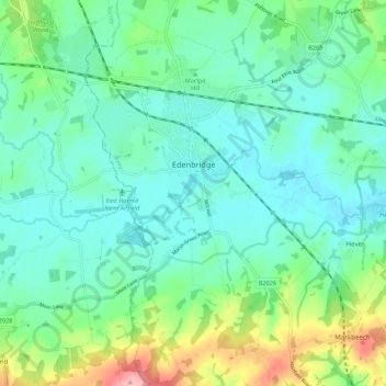
Name: Edenbridge topographic map, elevation, terrain.

Location: Edenbridge, Sevenoaks, Kent, England, United Kingdom (51.15695 0.03352 51.22461 0.09872)

Average elevation: 67 m

Minimum elevation: 34 m

Maximum elevation: 169 m

Other topographic maps

Click on a map to view its topography, its elevation and its terrain.

Brabourne Lees

United Kingdom > England > Kent > Ashford

Average elevation: 73 m

Chalk

United Kingdom > England > Kent > Gravesham

Average elevation: 27 m

Seasalter

United Kingdom > England > Kent > Canterbury

Average elevation: 12 m

Harbledown

United Kingdom > England > Kent > Canterbury

Average elevation: 41 m

Five Oak Green

United Kingdom > England > Kent > Tunbridge Wells

Average elevation: 28 m

Repton

United Kingdom > England > Kent > Ashford

Average elevation: 55 m

Sundries

United Kingdom > England > Kent > Borough of Swale > Bapchild

Average elevation: 33 m

Gear up for your next adventure:

🥘Camping Cookware Set - Compact nesting pots and pans for trail cooking
🛏️Sleeping Bag - Warm and compact sleeping bags for outdoor camping
🪑Insulated Seat Pad - Protect your seat from cold rocks and wet logs
🥾Hiking Shoes - Durable and comfortable shoes for trail hiking
🧴Bear Spray Holster - Quick-access carry for essential Canadian wilderness safety

As an Amazon Associate, this site earns from qualifying purchases at no extra cost to you.