Geolocate

Hawkhurst topographic map

Click on the map to display elevation.

About this map

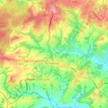
Name: Hawkhurst topographic map, elevation, terrain.

Location: Hawkhurst, Tunbridge Wells, Kent, England, United Kingdom (51.02239 0.45368 51.08324 0.54726)

Average elevation: 67 m

Minimum elevation: 10 m

Maximum elevation: 131 m

Other topographic maps

Click on a map to view its topography, its elevation and its terrain.

Five Oak Green

United Kingdom > England > Kent > Tunbridge Wells

Average elevation: 28 m

Gear up for your next adventure:

🧳Compression Sacks - Maximize space in your backpack by shrinking gear
👟Sport Hiking Sandals - Breathable footwear for water crossings and camp rest
🔭Outdoor Binoculars - Lightweight binoculars for birdwatching and hiking
🧭GPS Outdoor Watch - Smart watch for navigation and fitness tracking in nature
🛏️Camping Sleeping Mat - Comfortable mats for sleeping outdoors

As an Amazon Associate, this site earns from qualifying purchases at no extra cost to you.