
Faversham topographic map
Click on the map to display elevation.
About this map
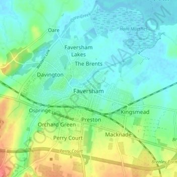
Name: Faversham topographic map, elevation, terrain.
Location: Faversham, Borough of Swale, Kent, England, United Kingdom (51.29561 0.86070 51.33720 0.91572)
Average elevation: 17 m
Minimum elevation: -2 m
Maximum elevation: 59 m
Other topographic maps
Click on a map to view its topography, its elevation and its terrain.
Faversham Creek
United Kingdom > England > Kent > Borough of Swale > Faversham > Oare
Average elevation: 8 m
Faversham Creek
United Kingdom > England > Kent > Borough of Swale > Faversham > Oare
Average elevation: 11 m
Hickmans Green
United Kingdom > England > Kent > Borough of Swale > Boughton Street
Average elevation: 63 m
Oare Creek
United Kingdom > England > Kent > Borough of Swale > Faversham > Oare
Average elevation: 6 m
Rodmersham Green
United Kingdom > England > Kent > Borough of Swale > Rodmersham Green
Average elevation: 48 m
Whitehill
United Kingdom > England > Kent > Borough of Swale > Painter's Forstal
Average elevation: 45 m