
Snodland topographic map
Click on the map to display elevation.
About this map
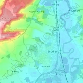
Name: Snodland topographic map, elevation, terrain.
Location: Snodland, Tonbridge and Malling, Kent, England, United Kingdom (51.31688 0.39016 51.35296 0.46043)
Average elevation: 39 m
Minimum elevation: -5 m
Maximum elevation: 178 m
Other topographic maps
Click on a map to view its topography, its elevation and its terrain.
Holborough Lakes
United Kingdom > England > Kent > Tonbridge and Malling > Snodland
Average elevation: 32 m