Geolocate

Appledore topographic map

Click on the map to display elevation.

About this map

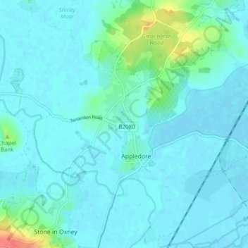
Name: Appledore topographic map, elevation, terrain.

Location: Appledore, Ashford, Kent, England, United Kingdom (51.01244 0.75249 51.06049 0.81714)

Average elevation: 9 m

Minimum elevation: -2 m

Maximum elevation: 64 m

Other topographic maps

Click on a map to view its topography, its elevation and its terrain.

Old Wives Lees

United Kingdom > England > Kent > Ashford

Average elevation: 66 m

Wye

United Kingdom > England > Kent > Ashford

Average elevation: 55 m

Hamstreet

United Kingdom > England > Kent > Ashford

Average elevation: 22 m

Pluckley Thorne

United Kingdom > England > Kent > Ashford > Pluckley

Average elevation: 53 m

Hassell Street

United Kingdom > England > Kent > Ashford > Hastingleigh

Average elevation: 134 m

Hinxhill

United Kingdom > England > Kent > Ashford

Average elevation: 51 m

Stonebridge Green

United Kingdom > England > Kent > Ashford > Egerton

Average elevation: 80 m

Potters Corner

United Kingdom > England > Kent > Ashford

Average elevation: 61 m

Flip Out

United Kingdom > England > Kent > Ashford

Average elevation: 43 m

Wye Downs

United Kingdom > England > Kent > Ashford

Average elevation: 118 m

Stonestreet Green

United Kingdom > England > Kent > Ashford > Aldington

Average elevation: 57 m

Standen

United Kingdom > England > Kent > Ashford > Biddenden

Average elevation: 38 m

Great Chart

United Kingdom > England > Kent > Ashford

Average elevation: 49 m

Aldington Frith

United Kingdom > England > Kent > Ashford

Average elevation: 44 m

St Michaels

United Kingdom > England > Kent > Ashford

Average elevation: 41 m

Boughton Lees

United Kingdom > England > Kent > Ashford

Average elevation: 79 m

Stone Abbage

United Kingdom > England > Kent > Ashford

Average elevation: 47 m

Cheeseman's Green

United Kingdom > England > Kent > Ashford

Average elevation: 44 m

Stubbs Cross

United Kingdom > England > Kent > Ashford

Average elevation: 43 m

Small Hythe

United Kingdom > England > Kent > Ashford

Average elevation: 26 m

Egerton Forstal

United Kingdom > England > Kent > Ashford

Average elevation: 50 m

Gear up for your next adventure:

🗺️Topographic Maps - Detailed maps to explore trails, mountains, and wilderness areas
🔥Camping Stove - Portable stoves to cook outdoors with ease
🥾Approach Shoes - Shoes designed for climbing approaches and rugged trails
🦯Trekking Poles - Reduced impact on joints for steep topographic climbs
💡Portable Camping Lamp - Rechargeable lamp for campsite lighting

As an Amazon Associate, this site earns from qualifying purchases at no extra cost to you.