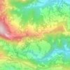
Karnali River topographic map
Click on the map to display elevation.
About this map

Name: Karnali River topographic map, elevation, terrain.
Location: Karnali River, Nepal (28.36487 80.69413 30.60309 82.03322)
Average elevation: 3,032 m
Minimum elevation: 139 m
Maximum elevation: 7,470 m
Other topographic maps
Click on a map to view its topography, its elevation and its terrain.
Mount Everest
Nepal > Koshi Province > Solukhumbu
Mount Everest (Nepali: सगरमाथा, romanized: Sagarmāthā; Standard Tibetan: ཇོ་མོ་གླང་མ, romanized: Chomolungma; Chinese: 珠穆朗玛峰; pinyin: Zhūmùlǎngmǎ Fēng) is Earth's highest mountain above sea level, located in the Mahalangur Himal sub-range of the Himalayas.…
Average elevation: 7,847 m
Himalayas
Nepal > Koshi Province > Solukhumbu
The Himalayas present a dramatic and varied topography characterized by towering peaks, deep valleys, and extensive glaciers. This majestic mountain range features some of the highest elevations on Earth, including Mount Everest, which rises to 29,035 feet. The terrain is marked by steep, jagged ridges and…
Average elevation: 7,555 m
Kathmandu
Nepal > Bagmati Province > Kathmandu
Kathmandu is located at an elevation of approximately 4,600 feet (1,400 meters) within the Kathmandu Valley. This valley is characterized by a bowl-like topography, encircled by the lower Himalayan ranges, which rise sharply in the north, culminating in peaks that exceed 24,000 feet (7,300 meters). The…
Average elevation: 1,538 m
Mount Everest
Nepal > Eastern Development Region > Khumjung
Mount Everest (Chinese: 珠穆朗玛 Zhūmùlǎngmǎ; Nepali: सगरमाथा Sagarmāthā; Tibetan: Chomolungma ཇོ་མོ་གླང་མ) is Earth's highest mountain above sea level, located in the Mahalangur Himal sub-range of the Himalayas. The China–Nepal border runs across its summit…
Average elevation: 7,841 m
Himalayas
Nepal > Koshi Province > Solukhumbu
The Himalayas, or Himalaya (/ˌhɪməˈleɪ.ə, hɪˈmɑːləjə/; Sanskrit: [ɦɪmaːlɐjɐ]; from Sanskrit himá 'snow, frost', and ā-laya 'dwelling, abode'), is a mountain range in Asia, separating the plains of the Indian subcontinent from the Tibetan Plateau. The range has some of the planet's highest…
Average elevation: 7,555 m


Mount Everest
Nepal > Koshi Province > Solukhumbu
Mount Everest (Nepali: सगरमाथा, romanized: Sagarmāthā; Tibetan: Chomolungma ཇོ་མོ་གླང་མ; Chinese: 珠穆朗玛峰; pinyin: Zhūmùlǎngmǎ Fēng) is Earth's highest mountain above sea level, located in the Mahalangur Himal sub-range of the Himalayas. The China–Nepal…
Average elevation: 7,850 m




Mount Everest
Nepal > Koshi Province > Solukhumbu
Mount Everest (Nepali: सगरमाथा, romanized: Sagarmāthā; Standard Tibetan: ཇོ་མོ་གླང་མ, romanized: Chomolungma; Chinese: 珠穆朗玛峰; pinyin: Zhūmùlǎngmǎ Fēng) is Earth's highest mountain above sea level, located in the Mahalangur Himal sub-range of the Himalayas.…
Average elevation: 7,847 m


Mount Everest
Nepal > Koshi Province > Solukhumbu
Mount Everest (Nepali: सगरमाथा, romanized: Sagarmāthā; Standard Tibetan: ཇོ་མོ་གླང་མ, romanized: Chomolungma; Chinese: 珠穆朗玛峰; pinyin: Zhūmùlǎngmǎ Fēng) is Earth's highest mountain above sea level, located in the Mahalangur Himal sub-range of the Himalayas.…
Average elevation: 7,847 m
Mount Everest
Nepal > Koshi Province > Solukhumbu
Mount Everest attracts many climbers, including highly experienced mountaineers. There are two main climbing routes, one approaching the summit from the southeast in Nepal (known as the standard route) and the other from the north in China. While not posing substantial technical climbing challenges on the…
Average elevation: 7,847 m
Mount Everest
Nepal > Koshi Province > Solukhumbu
Mount Everest is Earth's highest mountain above sea level, located in the Mahalangur Himal sub-range of the Himalayas. The China–Nepal border runs across its summit point. Its elevation (snow height) of 8,848.86 m (29,031 ft 8+1⁄2 in) was most recently established in 2020 by the Chinese and Nepali authorities.
Average elevation: 7,847 m




Lahan
Nepal > Madhesh Province > Siraha
Lahan (लहान) is a municipality in the Siraha district of Madhesh, Nepal. Lahan is the 36th densest municipality in the country, with a population of 102,031 spread out across 24 wards, the most wards of any Nepalese municipality. It is connected by the east-west highway. It is located nearly 261 km…
Average elevation: 115 m


Viewpoint (5225m)
Nepal > Gandaki Province > Gorkha > Larke Phedi - Dharmasala
Average elevation: 5,115 m


Melamchi
Nepal > Bagamati Province > Sindhupalchowk
The lower part of Melamchi valley has a sub-tropical climate, while the upper part has a cool temperate climate. The upper part of the valley receives more rainfall than in the lower part. Heavy rainfall occurs in June, July and August. Rainfall in January and February is the lowest. The annual average…
Average elevation: 1,216 m


Sarangkot
Nepal > Gandaki Province > Kaski > Pokhara
The Ward is located on Sarangkot, a hill on the western side of Pokhara with an altitude of 1600m. Sarangkot is known for its panoramic Himalayan views of Dhaulagiri, Annapurna and Manaslu. It also provides an expansive view of the city of Pokhara, from the extreme north to the south including Phewa Lake.…
Average elevation: 1,139 m


Lhotse
Nepal > Koshi Province > Solukhumbu
Lhotse (Nepali: ल्होत्से, romanized: L'hōtsē [lotse]; Standard Tibetan: ལྷོ་རྩེ, romanized: lho tse, lit. 'South Peak' [l̥otse]; Chinese: 洛子峰) is the fourth-highest mountain on Earth, after Mount Everest, K2, and Kangchenjunga. At an elevation of 8,516 metres (27,940…
Average elevation: 7,391 m






Pokhara
Pokhara is in the northwestern corner of the Pokhara Valley, which is a widening of the Seti Gandaki valley that lies in the region (Pahad) of the Himalayas. In this region the mountains rise very quickly, and within 30 kilometres (19 miles), the elevation rises from 1,000 to 7,500 metres (3,300 to 24,600…
Average elevation: 1,222 m




Mulpani Pipalbot
Nepal > Bagamati Province > Kathmandu > Kageshwori Manohara
Average elevation: 1,336 m
Namche Bazaar
Nepal > Koshi Province > Solukhumbu
Namche Bazaar is popular with trekkers in the Khumbu region, especially for altitude acclimatization, and is the gateway to the high Himalaya. The town has a number of lodgings, stores and internet cafés catering to the needs of visitors. There are German bakeries, little cafes and many restaurants. There is…
Average elevation: 3,526 m