Geolocate

Bidur topographic map

Click on the map to display elevation.

About this map
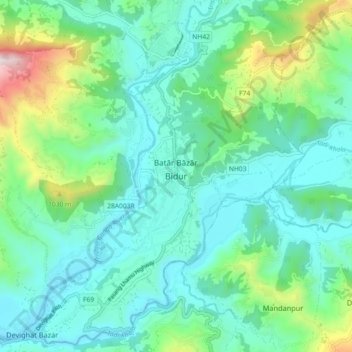
Name: Bidur topographic map, elevation, terrain.

Location: Bidur, Nuwakot, Bagamati Province, 44900, Nepal (27.85526 85.10645 27.93526 85.18645)

Average elevation: 693 m

Minimum elevation: 460 m

Maximum elevation: 1,538 m

Other topographic maps

Click on a map to view its topography, its elevation and its terrain.

Ducheshwar

Nepal > Bagamati Province > Nuwakot

Average elevation: 2,467 m

Kispang

Nepal > Bagamati Province > Nuwakot

Average elevation: 2,097 m

Shivapuri

Nepal > Bagamati Province > Nuwakot

Average elevation: 1,510 m

Kispang

Nepal > Bagamati Province > Nuwakot

Average elevation: 2,097 m

Kispang

Nepal > Bagamati Province > Nuwakot

Average elevation: 2,097 m

Tadi

Nepal > Bagamati Province > Nuwakot

Average elevation: 1,688 m

Shivapuri-03

Nepal > Bagamati Province > Nuwakot

Average elevation: 1,344 m

Tarkeshwar

Nepal > Bagamati Province > Nuwakot

Average elevation: 986 m

Kispang

Nepal > Bagamati Province > Nuwakot

Average elevation: 2,097 m

Gear up for your next adventure:

🦶Anti-Blister Balm - Prevents friction and hotspots during long ascents
💡Compact LED Flashlight - Powerful and portable flashlight for outdoor use
🧦Merino Wool Socks - Moisture-wicking comfort for long-distance hiking
🧢Sun Protection Cap - Breathable cap to protect from sun exposure
⛺Camping Groundsheet - Protect your tent from moisture and dirt

As an Amazon Associate, this site earns from qualifying purchases at no extra cost to you.