Geolocate

Changunarayan topographic map

Click on the map to display elevation.

About this map
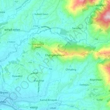
Name: Changunarayan topographic map, elevation, terrain.

Location: Changunarayan, Changunarayan Municipality, Bhaktapur, Bagamati Province, 44603, Nepal (27.67627 85.38928 27.75627 85.46928)

Average elevation: 1,381 m

Minimum elevation: 1,302 m

Maximum elevation: 1,961 m

Other topographic maps

Click on a map to view its topography, its elevation and its terrain.
Buddha Peace Garden

Nepal > Bagamati Province > Bhaktapur

Average elevation: 1,695 m

Bhaktapur-04

Nepal > Bagamati Province > Bhaktapur > Bhaktapur

Average elevation: 1,339 m

Bhaktapur-01

Nepal > Bagamati Province > Bhaktapur > Bhaktapur

Average elevation: 1,329 m

Manohara Nadi

Nepal > Bagamati Province > Bhaktapur > Dhuncho Pakha

Average elevation: 1,319 m

Suryabinayak-08

Nepal > Bagamati Province > Bhaktapur > Nankhel

Average elevation: 1,522 m

Suryabinayak-01

Nepal > Bagamati Province > Bhaktapur > Suryabinayak

Average elevation: 1,378 m

Gear up for your next adventure:

⛺Family Camping Tent - Spacious tent suitable for family camping trips
💡LED Headlamp - Hands-free illumination for night hiking and camping
🥾Trekking Poles - Adjustable trekking poles to reduce knee stress and improve stability
🛌Insulated Sleeping Pad - Critical thermal barrier between you and the cold ground
🧥Packable Rain Jacket - Breathable waterproof layer for unpredictable weather

As an Amazon Associate, this site earns from qualifying purchases at no extra cost to you.