Geolocate

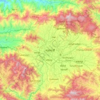
Kathmandu topographic map

Click on the map to display elevation.

Kathmandu

Kathmandu, officially "Kathmandu Metropolitan City", is the National capital Territory and most powerful city of Nepal with 845,767 inhabitants living in 105,649 households as of the 2021 Nepal census and approximately 4 million people in its urban agglomeration. It is located in the Kathmandu Valley, a large valley surrounded by hills in the high plateaus in central Nepal, at an altitude of 1,400 metres (4,600 feet).

Wikipedia (CC-BY-SA 3.0)

About this map

Name: Kathmandu topographic map, elevation, terrain.

Location: Kathmandu, Kathmandu Metropolitan City, Kathmandu, Bagmati Province, 46000, Nepal (27.54832 85.16058 27.86832 85.48058)

Average elevation: 1,538 m

Minimum elevation: 606 m

Maximum elevation: 2,733 m

Gear up for your next adventure:

🔨Vehicle Emergency Tool - Safety tool for remote road trips to trailheads
⛺Family Camping Tent - Spacious tent suitable for family camping trips
🔥Emergency Fire Starter - Reliable ignition source for all weather conditions
🧣Merino Neck Gaiter - Protects against wind, sun, and cold at high altitudes
🧴Bear Spray Holster - Quick-access carry for essential Canadian wilderness safety

As an Amazon Associate, this site earns from qualifying purchases at no extra cost to you.