Geolocate

Pumori topographic map

Click on the map to display elevation.

About this map
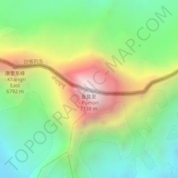
Name: Pumori topographic map, elevation, terrain.

Location: Pumori, Khumbu Pasang Lhamu, Solukhumbu, Koshi Province, Nepal (28.01580 86.82730 28.01590 86.82740)

Average elevation: 6,059 m

Minimum elevation: 5,393 m

Maximum elevation: 7,157 m

Other topographic maps

Click on a map to view its topography, its elevation and its terrain.

Khumbupasanglahmu

Nepal > Koshi Province > Solukhumbu

Average elevation: 4,909 m

Likhupike

Nepal > Koshi Province > Solukhumbu

Average elevation: 2,755 m

Sotang

Nepal > Koshi Province > Solukhumbu

Average elevation: 2,173 m

Khumbupasanglahmu-05

Nepal > Koshi Province > Solukhumbu

Average elevation: 5,232 m

West Ridge

Nepal > Koshi Province > Solukhumbu

Average elevation: 7,035 m

Gear up for your next adventure:

🛏️Camping Sleeping Mat - Comfortable mats for sleeping outdoors
🔋Lithium AA Batteries - Long-lasting power that performs in extreme cold
🦌Outdoor Trail Camera - Monitor wildlife activity near your favorite spots
🧭GPS Outdoor Watch - Smart watch for navigation and fitness tracking in nature
🧥Ultralight Puffy Jacket - Maximum warmth that packs down to the size of an orange

As an Amazon Associate, this site earns from qualifying purchases at no extra cost to you.