
Make a donation
Gear up for your next adventure:
As an Amazon Associate, this site earns from qualifying purchases at no extra cost to you.
Southampton Island topographic map
Click on the map to display elevation.
Make a donation
Gear up for your next adventure:
As an Amazon Associate, this site earns from qualifying purchases at no extra cost to you.
About this map
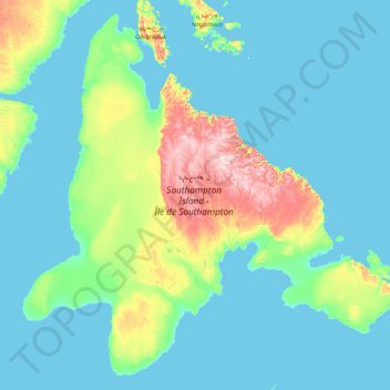
Name: Southampton Island topographic map, elevation, terrain.
Location: Southampton Island, X0C 0C0, Canada (63.10480 -87.21973 65.92301 -80.15021)
Average elevation: 52 m
Minimum elevation: -1 m
Maximum elevation: 595 m
Canada trails, hiking, mountain biking, running and outdoor activities
Make a donation
Gear up for your next adventure:
As an Amazon Associate, this site earns from qualifying purchases at no extra cost to you.
Other topographic maps
Click on a map to view its topography, its elevation and its terrain.
Toronto
Despite its deep ravines, Toronto is not remarkably hilly, but its elevation does increase steadily away from the lake. Elevation differences range from 76.5 metres (251 ft) above sea level at the Lake Ontario shore to 209 m (686 ft) ASL near the York University grounds in the city's north end at the…
Average elevation: 113 m
London
Canada > Ontario > London > London
London has a humid continental climate (Köppen Dfb), though due to its downwind location relative to Lake Huron and elevation changes across the city, it is virtually on the Dfa/Dfb (hot summer) boundary favouring the former climate zone to the southwest of the confluence of the South and North Thames Rivers,…
Average elevation: 268 m
Make a donation
Gear up for your next adventure:
As an Amazon Associate, this site earns from qualifying purchases at no extra cost to you.
Banff
Canada > Alberta > Banff > Banff
Banff is a town within Banff National Park in Alberta, Canada. It is located in Alberta's Rockies along the Trans-Canada Highway, approximately 126 km (78 mi) west of Calgary and 58 km (36 mi) east of Lake Louise. At 1,400 to 1,630 m (4,590 to 5,350 ft) above sea level, Banff is the community with the second…
Average elevation: 1,615 m
Make a donation
Gear up for your next adventure:
As an Amazon Associate, this site earns from qualifying purchases at no extra cost to you.
Whistler
Canada > British Columbia > Squamish-Lillooet Regional District > Whistler Resort Municipality > Whistler
Average elevation: 996 m
Make a donation
Gear up for your next adventure:
As an Amazon Associate, this site earns from qualifying purchases at no extra cost to you.
Make a donation
Gear up for your next adventure:
As an Amazon Associate, this site earns from qualifying purchases at no extra cost to you.
Pointe au Baril
Canada > Ontario > Parry Sound District > The Archipelago Township
Average elevation: 177 m
Make a donation
Gear up for your next adventure:
As an Amazon Associate, this site earns from qualifying purchases at no extra cost to you.
Make a donation
Gear up for your next adventure:
As an Amazon Associate, this site earns from qualifying purchases at no extra cost to you.
Paul Lake
Canada > British Columbia > Thompson-Nicola Regional District > Area P (Rivers and the Peaks)
Average elevation: 926 m
Mount Robson
Canada > British Columbia > Regional District of Fraser-Fort George > Area H (Robson Valley/Canoe)
The north face can be seen from Berg Lake, and reached by a 19 km (11.8 mi) hike. The lake is approximately 2 km long and lies at 1,646 m (5,400 ft) elevation. There are backcountry campgrounds at each end of the lake and a log shelter on its banks, named Hargreaves Shelter in honor of the Hargreaves family…
Average elevation: 3,042 m
Make a donation
Gear up for your next adventure:
As an Amazon Associate, this site earns from qualifying purchases at no extra cost to you.
Guelph
This region of Ontario has cold winters and warm, humid summers, falling into the Köppen climate classification Dfb zone, with moderately high rainfall and snowfall. It is generally a couple of degrees cooler than lower elevation regions on the Great Lakes shorelines, especially so in winter, the exception…
Average elevation: 344 m
Make a donation
Gear up for your next adventure:
As an Amazon Associate, this site earns from qualifying purchases at no extra cost to you.
Lethbridge
Canada > Alberta > Lethbridge
Its high elevation of 929 m (3,047.9 ft) and close proximity to the Rocky Mountains provides Lethbridge with cooler summers than other locations in the Canadian Prairies. These factors protect the city from strong northwest and southwest winds and contribute to frequent chinook winds during the winter.…
Average elevation: 918 m
Laurentian Mountains
One of Quebec's official regions is called Laurentides. The mountain range runs through four other regions; Capitale-Nationale, Outaouais, Lanaudière, and Mauricie. The elevation generally ranges from around 500 m (1,640 ft) to 1,000 m (3,280 ft) with Mont Raoul-Blanchard being its highest peak, at 1,166 m…
Average elevation: 348 m
Make a donation
Gear up for your next adventure:
As an Amazon Associate, this site earns from qualifying purchases at no extra cost to you.
Make a donation
Gear up for your next adventure:
As an Amazon Associate, this site earns from qualifying purchases at no extra cost to you.
Make a donation
Gear up for your next adventure:
As an Amazon Associate, this site earns from qualifying purchases at no extra cost to you.
Canmore
Canada > Alberta > Town of Canmore
Elevation Place opened in April 2013 as Canmore's new recreation facility. Construction of the facility began in 2012 to replace the Canmore Recreation Centre (the community's old facility). The facility offers an 8-lane 25m lap pool, a world class climbing wall developed by Walltopia, two cardio rooms, a…
Average elevation: 1,565 m
Saanich Peninsula
Canada > British Columbia > Capital Regional District > Central Saanich
Average elevation: 49 m
Make a donation
Gear up for your next adventure:
As an Amazon Associate, this site earns from qualifying purchases at no extra cost to you.
Sun Peaks
Canada > British Columbia > Thompson-Nicola Regional District > Sun Peaks Mountain Resort Municipality
Average elevation: 1,490 m
Make a donation
Gear up for your next adventure:
As an Amazon Associate, this site earns from qualifying purchases at no extra cost to you.
Peterborough
Canada > Ontario > Peterborough
Peterborough's topography is largely defined by land formations created by the receding Wisconsian glaciers 10,000–15,000 years ago. The South End and Downtown portions of the City sit on what was the bottom of the glacial Lake Peterborough—part of a glacial spillway created when glacial meltwaters from…
Average elevation: 235 m
Make a donation
Gear up for your next adventure:
As an Amazon Associate, this site earns from qualifying purchases at no extra cost to you.
Helm Glacier
Canada > British Columbia > Squamish-Lillooet Regional District > Area D (Elaho/Garibaldi)
Average elevation: 1,949 m
Cassiar Mountains
Canada > British Columbia > Peace River Regional District > Area B (Finlay Valley/Beatton Valley)
Average elevation: 935 m
Bowser
Canada > British Columbia > Regional District of Nanaimo > Area H (Lighthouse Country)
Average elevation: 52 m
Make a donation
Gear up for your next adventure:
As an Amazon Associate, this site earns from qualifying purchases at no extra cost to you.
Make a donation
Gear up for your next adventure:
As an Amazon Associate, this site earns from qualifying purchases at no extra cost to you.
Cultus Lake
Canada > British Columbia > Fraser Valley Regional District > Area H (Cultus Lake/Columbia Valley) > Cultus Lake
Average elevation: 191 m
Make a donation
Gear up for your next adventure:
As an Amazon Associate, this site earns from qualifying purchases at no extra cost to you.
Sunshine Valley
Canada > British Columbia > Fraser Valley Regional District > Area B (South Fraser Canyon/Sunshine Valley)
Average elevation: 1,030 m
Make a donation
Gear up for your next adventure:
As an Amazon Associate, this site earns from qualifying purchases at no extra cost to you.
Make a donation
Gear up for your next adventure:
As an Amazon Associate, this site earns from qualifying purchases at no extra cost to you.
Kingsgate
Canada > British Columbia > Regional District of Central Kootenay > Area B (Goat River Valley)
Average elevation: 979 m
Make a donation
Gear up for your next adventure:
As an Amazon Associate, this site earns from qualifying purchases at no extra cost to you.
Magdalen Islands
Canada > Quebec > Urban agglomeration of Les Îles-de-la-Madeleine
Average elevation: 1 m
Make a donation
Gear up for your next adventure:
As an Amazon Associate, this site earns from qualifying purchases at no extra cost to you.
Mount Logan
Due to active tectonic uplifting, Mount Logan is still rising in height (approximately 0.35 mm per year). Before 1992, the exact elevation of Mount Logan was unknown and measurements ranged from 5,959 to 6,050 metres (19,551 to 19,849 ft). In May 1992, a GSC expedition climbed Mount Logan and fixed the current…
Average elevation: 5,292 m
Make a donation
Gear up for your next adventure:
As an Amazon Associate, this site earns from qualifying purchases at no extra cost to you.
Lake Louise
Canada > Alberta > Improvement District No. 9
Lake Louise is a hamlet within Banff National Park in Alberta, Canada. Named after Princess Louise, Duchess of Argyll, it lies in Alberta's Rockies on the Bow River, 3 km (1.9 mi) northeast of the lake that shares its name. Initially settled in 1884 as an outpost for the Canadian Pacific Railway, Lake Louise…
Average elevation: 1,617 m
Nanoose Bay
Canada > British Columbia > Regional District of Nanaimo > Area E (Nanoose Bay)
Average elevation: 58 m
White Lake
Canada > British Columbia > Columbia-Shuswap Regional District > Area C (Blind Bay/Sorrento)
Average elevation: 606 m
Make a donation
Gear up for your next adventure:
As an Amazon Associate, this site earns from qualifying purchases at no extra cost to you.
Make a donation
Gear up for your next adventure:
As an Amazon Associate, this site earns from qualifying purchases at no extra cost to you.
Make a donation
Gear up for your next adventure:
As an Amazon Associate, this site earns from qualifying purchases at no extra cost to you.