
Jamaica topographic map
Interactive map
Click on the map to display elevation.
About this map
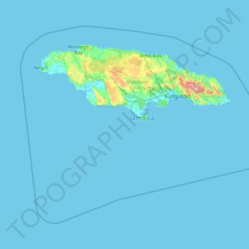
Name: Jamaica topographic map, elevation, terrain.
Location: Jamaica (16.58994 -78.57824 18.72564 -75.75411)
Average elevation: 39 m
Minimum elevation: -2 m
Maximum elevation: 2,198 m
Coral reef ecosystems are important because they provide people with a source of livelihood, food, recreation, and medicinal compounds and protect the land on which they live. Jamaica relies on the ocean and its ecosystem for its development. However, the marine life in Jamaica is also being affected. There could be many factors that contribute to marine life not having the best health. Jamaica's geological origin, topographical features and seasonal high rainfall make it susceptible to a range of natural hazards that can affect the coastal and oceanic environments. These include storm surge, slope failures (landslides), earthquakes, floods and hurricanes. Coral reefs in the Negril Marine Park (NMP), Jamaica, have been increasingly impacted by nutrient pollution and macroalgal blooms following decades of intensive development as a major tourist destination. Another one of those factors could include tourism: being that Jamaica is a very touristy place, the island draws numerous people traveling here from all over the world. The Jamaican tourism industry accounts for 32% of total employment and 36% of the country's GDP and is largely based on the sun, sea and sand, the last two of these attributes being dependent on healthy coral reef ecosystems. Because of Jamaica's tourism, they have developed a study to see if the tourist would be willing to help financially to manage their marine ecosystem because Jamaica alone is unable to. The ocean connects all the countries all over the world, however, everyone and everything is affecting the flow and life in the ocean. Jamaica is a very touristy place specifically because of their beaches. If their oceans are not functioning at their best then the well-being of Jamaica and the people who live there will start to deteriorate. According to the OECD, oceans contribute $1.5 trillion annually in value-added to the overall economy. A developing country on an island will get the majority of their revenue from their ocean.
Other topographic maps
Click on a map to view its topography, its elevation and its terrain.
Edmonton
Canada > Alberta > Division No. 11
Edmonton, Division No. 11, Alberta, Canada
Average elevation: 690 m
Winnipeg
Canada > Manitoba > Division No. 11
Winnipeg, Division No. 11, Manitoba, Canada
Average elevation: 236 m
Vancouver
Canada > British Columbia > Metro Vancouver Regional District
Vancouver, Metro Vancouver Regional District, British Columbia, Canada
Average elevation: 34 m
Colorado Springs
United States > Colorado > El Paso County
Colorado Springs, El Paso County, Colorado, United States
Average elevation: 2,252 m
Canada
Canada
Average elevation: 254 m
Chilliwack
Canada > British Columbia > Fraser Valley Regional District
Chilliwack, Fraser Valley Regional District, British Columbia, Canada
Average elevation: 240 m
Scarborough
Scarborough, Toronto, Golden Horseshoe, Ontario, Canada
Average elevation: 138 m
Vancouver Island
Vancouver Island, British Columbia, Canada
Average elevation: 411 m
Victoria
Canada > British Columbia > Capital Regional District
Victoria, Capital Regional District, British Columbia, Canada
Average elevation: 17 m
Montreal
Canada > Quebec > Urban agglomeration of Montreal
Montreal, Urban agglomeration of Montreal, Montreal (administrative region), Quebec, Canada
Average elevation: 29 m
Oakville
Canada > Ontario > Halton Region
Oakville, Halton Region, Golden Horseshoe, Ontario, Canada
Average elevation: 104 m
Kamloops
Canada > British Columbia > Thompson-Nicola Regional District
Kamloops, Thompson-Nicola Regional District, British Columbia, Canada
Average elevation: 833 m
Mission
Canada > British Columbia > Fraser Valley Regional District
Mission, Fraser Valley Regional District, British Columbia, Canada
Average elevation: 345 m
USA
United States > Texas > Tarrant County > Arlington
USA, Arlington, Tarrant County, Texas, 76011, United States
Average elevation: 170 m
Lubbock
United States > Texas > Lubbock County
Lubbock, Lubbock County, Texas, United States
Average elevation: 983 m
Worcester County
Worcester County, Massachusetts, United States
Average elevation: 192 m
Yellowstone National Park
Yellowstone National Park, Wyoming, United States
Average elevation: 2,450 m
Manitoulin Island
Canada > Ontario > Manitoulin District
Manitoulin Island, Manitoulin District, Northeastern Ontario, Ontario, Canada
Average elevation: 194 m
Baton Rouge
United States > Louisiana > East Baton Rouge Parish
Baton Rouge, East Baton Rouge Parish, Louisiana, United States
Average elevation: 13 m
Metro Vancouver Regional District
Metro Vancouver Regional District, British Columbia, Canada
Average elevation: 343 m
Kitchener
Canada > Ontario > Region of Waterloo
Kitchener, Region of Waterloo, Southwestern Ontario, Ontario, Canada
Average elevation: 336 m
Algonquin Provincial Park
Canada > Ontario > Nipissing District > Unorganized South Nipissing
Algonquin Provincial Park, Unorganized South Nipissing, Nipissing District, Northeastern Ontario, Ontario, Canada
Average elevation: 386 m
Quebec
Canada > Quebec > Urban agglomeration of Québec
Quebec, Urban agglomeration of Québec, Capitale-Nationale, Quebec, Canada
Average elevation: 117 m
Burnaby
Canada > British Columbia > Metro Vancouver Regional District
Burnaby, Metro Vancouver Regional District, British Columbia, Canada
Average elevation: 59 m
Surrey
Canada > British Columbia > Metro Vancouver Regional District
Surrey, Metro Vancouver Regional District, British Columbia, Canada
Average elevation: 28 m