
Morbello topographic map
Click on the map to display elevation.
About this map
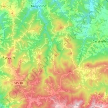
Name: Morbello topographic map, elevation, terrain.
Location: Morbello, Alessandria, Piemonte, Italia (44.54668 8.48964 44.63520 8.55103)
Average elevation: 450 m
Minimum elevation: 186 m
Maximum elevation: 820 m
Other topographic maps
Click on a map to view its topography, its elevation and its terrain.
Cosola
Italia > Piemonte > Alessandria
Il centro è situato in alta Val Borbera, alle pendici dei monti Chiappo (1.699 m), Ebro (1.701 m) e Cavalmurone (1.670 m), ad un'altitudine di 894 m. La frazione si trova sulla strada per Zerba (PC) in val Boreca e per Santa Margherita di Staffora (PV) in valle Staffora ed è una località di villeggiatura.
Average elevation: 1,234 m
Regione Madonna
Italia > Piemonte > Alessandria > Camagna Monferrato > Camagna Monferrato
Average elevation: 175 m
Val Borbera Adventure Park
Italia > Piemonte > Alessandria > Mongiardino Ligure > Fubbiano
Average elevation: 580 m
Castelceriolo
Italia > Piemonte > Alessandria > Alessandria
Castelceriolo è una frazione del comune di Alessandria, situato ad est del territorio comunale sulla riva destra della Bormida e confina con i territori di Lobbi, San Giuliano Nuovo e Spinetta Marengo anch'essi frazioni di Alessandria. Il borgo sorge ad un'altitudine di 93 metri s.l.m. sul declino della…
Average elevation: 91 m