Geolocate

Rivere topographic map

Click on the map to display elevation.

About this map

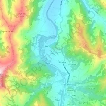
Name: Rivere topographic map, elevation, terrain.

Location: Rivere, Cartosio, Alessandria, Piemonte, Italia (44.59125 8.39128 44.63125 8.43128)

Average elevation: 312 m

Minimum elevation: 169 m

Maximum elevation: 599 m

Gear up for your next adventure:

🧦Outdoor Socks - Durable socks designed for hiking and outdoor sports
🥾Lightweight Hiking Shoes - Comfortable shoes for day hikes
👟Sport Hiking Sandals - Breathable footwear for water crossings and camp rest
🥾Mountain Hiking Boots - High-traction boots for rocky terrain
🩹Moleskin Blister Pads - Direct protection for painful foot pressure points

As an Amazon Associate, this site earns from qualifying purchases at no extra cost to you.