
Morris topographic map
Click on the map to display elevation.
About this map
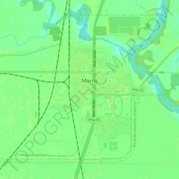
Name: Morris topographic map, elevation, terrain.
Location: Morris, Manitoba, Canada (49.33980 -97.39160 49.36389 -97.34740)
Average elevation: 237 m
Minimum elevation: 229 m
Maximum elevation: 240 m
Manitoba trails, hiking, mountain biking, running and outdoor activities
Other topographic maps
Click on a map to view its topography, its elevation and its terrain.
Clear Lake
Canada > Manitoba > Division No. 18 > Rural Municipality of Grahamdale
Average elevation: 251 m
Easterville
Canada > Manitoba > Division No. 21 > Unorganized Division No. 21
Average elevation: 260 m
Riding Mountain National Park
The climate in the Riding Mountain region is similar to that of other regions of southwestern Manitoba. Under the Köppen classification it has a continental climate. It includes grasslands, upland boreal and eastern deciduous forest ecosystems. The park has hot summers and cold winters, with annual rainfall…
Average elevation: 488 m
Rowland Lake
Canada > Manitoba > Division No. 15 > Rural Municipality of Rosedale
Average elevation: 692 m
Bakers Narrows
Canada > Manitoba > Division No. 21 > Unorganized Division No. 21
Average elevation: 297 m
Elphinstone
Canada > Manitoba > Division No. 15 > Rural Municipality of Yellowhead
Average elevation: 583 m
West Hawk Lake
Canada > Manitoba > Division No. 1 > Unorganized Division No. 1
Average elevation: 349 m
Wasagaming
Canada > Manitoba > Unorganized Division No. 17
Wasagaming has a subarctic climate (Dfc) due to its northerly location and high elevation. Winters are extremely cold and relatively dry with little chance of a mid-winter thaw. The average annual temperature is 0.7 °C (33.3 °F). Annual precipitation is 488 mm (19.2 in).
Average elevation: 630 m
Red River Floodway
Canada > Manitoba > Rural Municipality of Springfield > Winnipeg
Average elevation: 236 m