Geolocate

Minnedosa topographic map

Click on the map to display elevation.

About this map

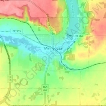
Name: Minnedosa topographic map, elevation, terrain.

Location: Minnedosa, Manitoba, R0J 1E0, Canada (50.23311 -99.88451 50.26266 -99.81563)

Average elevation: 542 m

Minimum elevation: 504 m

Maximum elevation: 588 m

Manitoba trails, hiking, mountain biking, running and outdoor activities

Gear up for your next adventure:

🌡️Emergency Mylar Blankets - Compact thermal protection for unexpected nights outdoors
🧭GPS Handheld Device - Reliable GPS navigation for outdoor adventures
🥾Hiking Shorts - Breathable shorts suitable for summer hikes
🥾Mountain Hiking Boots - High-traction boots for rocky terrain
🥾Trail Hiking Shoes - Durable shoes designed for rugged trails

As an Amazon Associate, this site earns from qualifying purchases at no extra cost to you.