Geolocate

Onanole topographic map

Click on the map to display elevation.

About this map

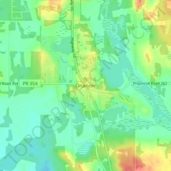
Name: Onanole topographic map, elevation, terrain.

Location: Onanole, Municipality of Harrison Park, Division No. 15, Manitoba, R0J 1N0, Canada (50.60355 -99.98904 50.64355 -99.94904)

Average elevation: 627 m

Minimum elevation: 610 m

Maximum elevation: 663 m

Division No. 15 trails, hiking, mountain biking, running and outdoor activities

Other topographic maps

Click on a map to view its topography, its elevation and its terrain.

Gear up for your next adventure:

🧥Packable Rain Jacket - Breathable waterproof layer for unpredictable weather
👟Leg Gaiters - Keep debris, mud, and snow out of your boots
🥾Approach Shoes - Shoes designed for climbing approaches and rugged trails
🩹Compact First Aid Kit - Pre-packed essentials for common trail injuries
🥾Trail Hiking Socks - Comfortable socks to prevent blisters and fatigue

As an Amazon Associate, this site earns from qualifying purchases at no extra cost to you.