
Ukraine topographic map
Click on the map to display elevation.
Ukraine
Ukraine's topography is characterized by a striking contrast of features across its vast landscape. The country predominantly consists of fertile plains and steppes, especially in the central and southern regions, where elevations typically range from sea level to around 600 meters (1,969 feet) above sea level. This expansive steppe is interspersed with plateaus and lowlands, contributing to Ukraine's reputation as one of the world's breadbaskets due to its rich black soil ideal for agriculture. In stark contrast, the western part of the country is home to the Carpathian Mountains, with the highest peak, Mount Hoverla, rising to 2,061 meters (6,762 feet). Additionally, the southern tip of Ukraine features the Crimean Mountains, creating a unique semi-tropical climate that attracts tourism. Overall, Ukraine's diverse terrain includes significant rivers like the Dnipro, which further enhances the region's geographical richness.
About this map
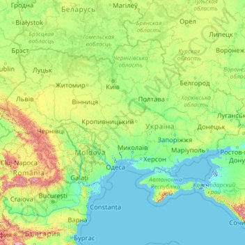
Name: Ukraine topographic map, elevation, terrain.
Location: Ukraine (44.18460 22.13706 52.37975 40.22781)
Average elevation: 183 m
Minimum elevation: -5 m
Maximum elevation: 2,993 m
Other topographic maps
Click on a map to view its topography, its elevation and its terrain.
Toronto
Despite its deep ravines, Toronto is not remarkably hilly, but its elevation does increase steadily away from the lake. Elevation differences range from 76.5 metres (251 ft) above sea level at the Lake Ontario shore to 209 m (686 ft) ASL near the York University grounds in the city's north end at the…
Average elevation: 113 m
Banff
Canada > Alberta > Banff > Banff
Banff is a town within Banff National Park in Alberta, Canada. It is located in Alberta's Rockies along the Trans-Canada Highway, approximately 126 km (78 mi) west of Calgary and 58 km (36 mi) east of Lake Louise. At 1,400 to 1,630 m (4,590 to 5,350 ft) above sea level, Banff is the community with the second…
Average elevation: 1,615 m
London
Canada > Ontario > London > London
London has a humid continental climate (Köppen Dfb), though due to its downwind location relative to Lake Huron and elevation changes across the city, it is virtually on the Dfa/Dfb (hot summer) boundary favouring the former climate zone to the southwest of the confluence of the South and North Thames Rivers,…
Average elevation: 268 m
Salt Lake City
United States > Utah > Salt Lake County > Salt Lake City
Salt Lake City has an area of 110.4 square miles (286 km2) and an average elevation of 4,327 feet (1,319 m) above sea level. The lowest point within the boundaries of the city is 4,210 feet (1,280 m) near the Jordan River and the Great Salt Lake, and the highest is Grandview Peak, at 9,410 feet (2,868 m).
Average elevation: 1,625 m
Caspian Sea
Over 130 rivers provide inflow to the Caspian, with the Volga River being the largest. A second affluent, the Ural River, flows in from the north, and the Kura River flows into the sea from the west. In the past, the Amu Darya (Oxus) of Central Asia in the east often changed course to empty into the Caspian…
Average elevation: -29 m
Peterborough
Canada > Ontario > Peterborough
Peterborough's topography is largely defined by land formations created by the receding Wisconsian glaciers 10,000–15,000 years ago. The South End and Downtown portions of the City sit on what was the bottom of the glacial Lake Peterborough—part of a glacial spillway created when glacial meltwaters from…
Average elevation: 235 m
Guelph
This region of Ontario has cold winters and warm, humid summers, falling into the Köppen climate classification Dfb zone, with moderately high rainfall and snowfall. It is generally a couple of degrees cooler than lower elevation regions on the Great Lakes shorelines, especially so in winter, the exception…
Average elevation: 344 m
Great Dividing Range
The Great Dividing Range, also known as the East Australian Cordillera or the Eastern Highlands, is a cordillera system in eastern Australia consisting of an expansive collection of mountain ranges, plateaus and rolling hills, that runs roughly parallel to the east coast of Australia and forms the…
Average elevation: 117 m
Dease Lake
Canada > British Columbia > Regional District of Kitimat-Stikine > Area F (Dease Lake)
Dease Lake has a subarctic climate (Köppen Dfc), typical of northern British Columbia. Summers are mild, coupled with chilly nights while winters are severely cold and snowy, with annual snowfall averaging 212.8 cm (83.78 in). Autumn typically begins by early September and lasts into October when winter…
Average elevation: 898 m
Cultus Lake
Canada > British Columbia > Fraser Valley Regional District > Area H (Cultus Lake/Columbia Valley) > Cultus Lake
Average elevation: 191 m
Burnaby
Canada > British Columbia > Metro Vancouver Regional District > Burnaby
Burnaby occupies 98.60 square kilometres (38.07 sq mi) and is located at the geographic centre of the Metro Vancouver area and home to the Metro Vancouver regional government in Metrotown. Situated between the city of Vancouver on the west and Port Moody, Coquitlam, and New Westminster on the east, Burnaby is…
Average elevation: 144 m
Sioux Narrows
Canada > Ontario > Kenora District > Sioux Narrows-Nestor Falls Township
Average elevation: 329 m
Mist Mountain
Canada > Alberta > Kananaskis Improvement District
Mist Mountain is a mountain located alongside Highway 40 in the Canadian Rockies of Alberta, Canada. It reaches an elevation of 3,140 m (10,300 ft) and is visible from Highway 40 and the Sheep River.
Average elevation: 2,515 m
150 Mile House
Canada > British Columbia > Cariboo Regional District > Area F (Horsefly/Likely/150 Mile House)
Average elevation: 789 m
Kokanee Creek
Canada > British Columbia > Regional District of Central Kootenay > Area E (Balfour/Cottonwood Lake)
Average elevation: 2,022 m
Nose Hill Park
Names currently associated with topographical features in and near Nose Hill Park reflect the impact of the European newcomers and European trade goods on the Peigan. For example, Spy Hill, the westward extension of Nose Hill, derived its present name from the aboriginal practice of communicating with distant…
Average elevation: 1,174 m
Mammoth Lakes
United States of America > California > Mammoth Lakes
Mammoth Lakes is a town in Mono County, California, the county's only incorporated community. It is located immediately to the east of Mammoth Mountain, at an elevation of 7,880 feet (2,400 m). As of the 2010 United States Census, the population was 8,234, reflecting a 16% increase from the 2000 Census.
Average elevation: 2,184 m
Clarence Creek
Canada > Ontario > Prescott and Russell Counties > Clarence-Rockland
Average elevation: 66 m
The Bugaboos
Canada > British Columbia > Regional District of East Kootenay > Area G (Forster Creek/Mount Assiniboine)
Average elevation: 2,412 m
Tête-à-la-Baleine
Canada > Quebec > Le Golfe-du-Saint-Laurent > Côte-Nord-du-Golfe-du-Saint-Laurent
Average elevation: 24 m
Anyox
Canada > British Columbia > Regional District of Kitimat-Stikine > Area A (Nass Valley/Bell Irving)
Average elevation: 110 m
Mara Lake
Canada > British Columbia > Columbia-Shuswap Regional District > Area E (Eagle River Valley) > Swansea Point
The lake is 35.3 kilometres (21.9 mi) long. The surface area is about 1,943 hectares (4,800 acres) and elevation is 338 metres (1,109 ft) above sea level. The mean and maximum depth is 18 metres (59 ft).
Average elevation: 826 m
Chehalis Lake
Canada > British Columbia > Fraser Valley Regional District > Area C (Sasquatch Country)
Average elevation: 735 m
Coast Mountains
Canada > British Columbia > Area A (Seymour Inlet/Knight Inlet)
The Coast Mountains are part of the Pacific Ring of Fire—the ring of volcanoes and associated mountains around the Pacific Ocean—and contain some of British Columbia's highest mountains. Mount Waddington is the highest mountain of the Coast Mountains and the highest that lies entirely within British…
Average elevation: 1,951 m
Canmore
Canada > Alberta > Town of Canmore
Elevation Place opened in April 2013 as Canmore's new recreation facility. Construction of the facility began in 2012 to replace the Canmore Recreation Centre (the community's old facility). The facility offers an 8-lane 25m lap pool, a world class climbing wall developed by Walltopia, two cardio rooms, a…
Average elevation: 1,565 m
Cochrane
Canada > Alberta > Town of Cochrane > Cochrane
Cochrane is situated at the base of Big Hill in the Bow River Valley. It sits at an elevation of 1,186 m (3,891 ft). The town is intersected by Highway 1A and Highway 22. Cochrane has a reputation for its western culture, which can easily be felt when one wanders the streets (particularly Main Street). The…
Average elevation: 1,205 m
Harrison River
Canada > British Columbia > Fraser Valley Regional District > Kent > Harrison Mills
Average elevation: 45 m
Woodlot 0007
Canada > British Columbia > Metro Vancouver Regional District > Maple Ridge
Average elevation: 322 m
Grande Prairie
Canada > Alberta > Grande Prairie
Grande Prairie is located just north of the 55th parallel north, and is 465 km (289 mi) northwest of Edmonton, lying at an elevation of 669 m (2,195 ft) above sea level. The city is surrounded by farmland to the north, east, and west. To the south lies a vast boreal forest with aspen, tamarack, lodgepole pine,…
Average elevation: 668 m
Elbow Lake
Canada > British Columbia > Cariboo Regional District > Area F (Horsefly/Likely/150 Mile House)
Average elevation: 959 m
Lucknow
India > Uttar Pradesh > Lucknow
Lucknow stands at an elevation of approximately 123 metres (404 ft) above sea level. The city had an area of 402 km2 (155 square miles) until December 2019, when 88 villages were added to the municipal limits and the area increased to 631 km2 (244 square miles). Bounded on the east by Barabanki, on the west by…
Average elevation: 120 m
Lethbridge
Canada > Alberta > Lethbridge
Its high elevation of 929 m (3,047.9 ft) and close proximity to the Rocky Mountains provides Lethbridge with cooler summers than other locations in the Canadian Prairies. These factors protect the city from strong northwest and southwest winds and contribute to frequent chinook winds during the winter.…
Average elevation: 918 m
Laurentian Mountains
One of Quebec's official regions is called Laurentides. The mountain range runs through four other regions; Capitale-Nationale, Outaouais, Lanaudière, and Mauricie. The elevation generally ranges from around 500 m (1,640 ft) to 1,000 m (3,280 ft) with Mont Raoul-Blanchard being its highest peak, at 1,166 m…
Average elevation: 348 m
Mundy Park
Canada > British Columbia > Metro Vancouver Regional District > Coquitlam
Average elevation: 139 m
Carroll Lake
Canada > Ontario > Kenora District > Unorganized Kenora District
Average elevation: 338 m
Chignecto Isthmus
Canada > Nova Scotia > Municipality of the County of Cumberland > Fort Lawrence
Average elevation: 14 m
Andes
Argentina > Mendoza > Distrito Las Cuevas
The Andes Mountains are the highest mountain range outside Asia. The highest mountain outside Asia, Argentina's Mount Aconcagua, rises to an elevation of about 6,961 m (22,838 ft) above sea level. The peak of Chimborazo in the Ecuadorian Andes is farther from the Earth's center than any other location on the…
Average elevation: 6,208 m
Grouse Mountain
Canada > British Columbia > Metro Vancouver Regional District
Grouse Mountain is one of the North Shore Mountains of the Pacific Ranges in the District Municipality of North Vancouver, British Columbia, Canada. With a maximum elevation of over 1,200 m (4,100 feet) at its peak, the mountain is the site of an alpine ski area, Grouse Mountain Resort, which overlooks Greater…
Average elevation: 968 m