
Jefferson County topographic map
Interactive map
Click on the map to display elevation.
About this map
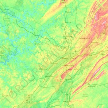
Name: Jefferson County topographic map, elevation, terrain.
Location: Jefferson County, Alabama, United States (33.24626 -87.34248 33.84341 -86.51651)
Average elevation: 173 m
Minimum elevation: 70 m
Maximum elevation: 451 m
The county is located within the Ridge-and-Valley Appalachians, with the highest point in the county being found at Shades Mountain, at an elevation of 1,150 ft. Another significant mountain located within the county is Red Mountain, which runs to the south of downtown Birmingham and separates the city from the suburb of Homewood. Many other mountains and valleys make up the majority of the county's diverse geography.
Other topographic maps
Click on a map to view its topography, its elevation and its terrain.
Huntsville
United States > Alabama > Madison County
Huntsville, Madison County, Alabama, United States
Average elevation: 230 m
Silk Stocking Historic District
United States > Alabama > Talladega County > Talladega
Silk Stocking Historic District, Talladega, Talladega County, Alabama, 36160, United States
Average elevation: 186 m
St. Stephens
United States > Alabama > Washington County > Saint Stephens
St. Stephens, Saint Stephens, Washington County, Alabama, 36569, United States
Average elevation: 35 m
Sheppard
United States > Alabama > Wilcox County
Sheppard, Wilcox County, Alabama, United States
Average elevation: 21 m
Fort McDermott
United States > Alabama > Baldwin County > Spanish Fort
Fort McDermott, Spanish Fort, Baldwin County, Alabama, 36527, United States
Average elevation: 18 m
Fishing Lake
United States > Alabama > Clarke County
Fishing Lake, Clarke County, Alabama, United States
Average elevation: 4 m
Union Springs
United States > Alabama > Bullock County
Union Springs, Bullock County, Alabama, 36089, United States
Average elevation: 139 m
Hawaii Island
United States > Alabama > Tallapoosa County
Hawaii Island, Tallapoosa County, Alabama, United States
Average elevation: 149 m
Jackson Heights
United States > Alabama > Colbert County > Muscle Shoals
Jackson Heights, Muscle Shoals, Colbert County, Alabama, 35661, United States
Average elevation: 160 m
Masseyline
United States > Alabama > Jefferson County
Masseyline, Jefferson County, Alabama, 35172, United States
Average elevation: 173 m
Notasulga
United States > Alabama > Macon County
Notasulga, Macon County, Alabama, 36866, United States
Average elevation: 149 m
Tillmans Corner
United States > Alabama > Mobile County > Tillmans Corner
Tillmans Corner, Mobile County, Alabama, 36619, United States
Average elevation: 39 m
Jones Lake
United States > Alabama > Lee County > Auburn
Jones Lake, Auburn, Lee County, Alabama, United States
Average elevation: 187 m
Limestone County
Limestone County, Alabama, United States
Average elevation: 209 m
Stevenson
United States > Alabama > Jackson County
Stevenson, Jackson County, Alabama, 35772, United States
Average elevation: 247 m
Scottland
United States > Alabama > Bullock County
Scottland, Bullock County, Alabama, 36059, United States
Average elevation: 150 m
Tabernacle
United States > Alabama > Coffee County
Tabernacle, Coffee County, Alabama, United States
Average elevation: 119 m
Bessemer
United States > Alabama > Jefferson County
Bessemer, Jefferson County, Alabama, United States
Average elevation: 175 m
Sunshine Village
United States > Alabama > Montgomery County > Montgomery
Sunshine Village, Montgomery, Montgomery County, Alabama, 36119, United States
Average elevation: 65 m
Daphne
United States > Alabama > Baldwin County
Daphne, Baldwin County, Alabama, 36526, United States
Average elevation: 25 m
Fairhope
United States > Alabama > Baldwin County
Fairhope, Baldwin County, Alabama, 36533, United States
Average elevation: 17 m
Flomaton
United States > Alabama > Escambia County
Flomaton, Escambia County, Alabama, 36441, United States
Average elevation: 42 m
Bridgehead
United States > Alabama > Baldwin County > Spanish Fort
Bridgehead, Spanish Fort, Baldwin County, Alabama, 36527, United States
Average elevation: 22 m
Avon Park
United States > Alabama > Jefferson County > Birmingham
Avon Park, Birmingham, Jefferson County, Alabama, 35212, United States
Average elevation: 189 m
Gulf Shores
United States > Alabama > Baldwin County
Gulf Shores, Baldwin County, Alabama, 36542, United States
Average elevation: 4 m
Decatur
United States > Alabama > Morgan County
Decatur, Morgan County, Alabama, United States
Average elevation: 186 m
Pine Ridge
United States > Alabama > DeKalb County
Pine Ridge, DeKalb County, Alabama, United States
Average elevation: 312 m
Madison
United States > Alabama > Jefferson County > Brighton
Madison, Brighton, Jefferson County, Alabama, 35228, United States
Average elevation: 163 m
Martins
United States > Alabama > Jefferson County > Birmingham
Martins, Birmingham, Jefferson County, Alabama, 35028, United States
Average elevation: 176 m
Simpson
United States > Alabama > Tallapoosa County
Simpson, Tallapoosa County, Alabama, 36256, United States
Average elevation: 237 m
Auburn
United States > Alabama > Lee County
Auburn, Lee County, Alabama, United States
Average elevation: 200 m
Melborne
United States > Alabama > Lamar County
Melborne, Lamar County, Alabama, United States
Average elevation: 83 m
Hanceville
United States > Alabama > Cullman County
Hanceville, Cullman County, Alabama, United States
Average elevation: 177 m
Trussville
United States > Alabama > Jefferson County
Trussville, Jefferson County, Alabama, United States
Average elevation: 265 m
Center Point
United States > Alabama > Jefferson County
Center Point, Jefferson County, Alabama, 35215, United States
Average elevation: 245 m
Red Wine
United States > Alabama > Jefferson County > Graysville
Red Wine, Graysville, Jefferson County, Alabama, 35073, United States
Average elevation: 162 m
Theodore
United States > Alabama > Mobile County > Theodore
Theodore, Mobile County, Alabama, 36582, United States
Average elevation: 24 m
Tuscaloosa
United States > Alabama > Tuscaloosa County
Tuscaloosa, Tuscaloosa County, Alabama, United States
Average elevation: 97 m
Douglasville
United States > Alabama > Jefferson County > Birmingham > Douglasville
Douglasville, Birmingham, Jefferson County, Alabama, 35234, United States
Average elevation: 182 m
Pine Grove
United States > Alabama > Mobile County > Mobile > Pine Grove
Pine Grove, Mobile, Mobile County, Alabama, 36607, United States
Average elevation: 30 m
Dothan
United States > Alabama > Houston County > Dothan
Dothan, Houston County, Alabama, United States
Average elevation: 88 m
Pelham
United States > Alabama > Shelby County
Pelham, Shelby County, Alabama, 35124, United States
Average elevation: 173 m
Ozark
United States > Alabama > Dale County > Ozark
Ozark, Dale County, Alabama, 36361, United States
Average elevation: 103 m
Foley
United States > Alabama > Baldwin County
Foley, Baldwin County, Alabama, 36535, United States
Average elevation: 20 m