Geolocate

Pine Ridge topographic map

Click on the map to display elevation.

About this map

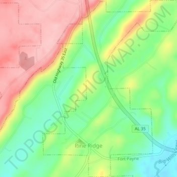
Name: Pine Ridge topographic map, elevation, terrain.

Location: Pine Ridge, DeKalb County, Alabama, United States (34.43453 -85.79384 34.46347 -85.76529)

Average elevation: 312 m

Minimum elevation: 238 m

Maximum elevation: 397 m

Gear up for your next adventure:

🛰️Satellite Messenger - Emergency communication for areas with no cell service
Lightweight Backpacking Tent - Compact tent for efficient hiking trips
🧭GPS Tracker - Track your location in remote areas safely
🧴Bear Spray Holster - Quick-access carry for essential Canadian wilderness safety
🥾Light Trekking Boots - Supportive boots for multi-day treks

As an Amazon Associate, this site earns from qualifying purchases at no extra cost to you.