Geolocate

Bessemer topographic map

Click on the map to display elevation.

About this map

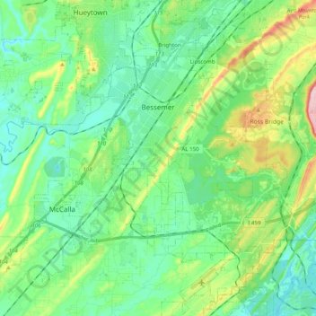
Name: Bessemer topographic map, elevation, terrain.

Location: Bessemer, Jefferson County, Alabama, United States (33.30019 -87.07129 33.44987 -86.85609)

Average elevation: 175 m

Minimum elevation: 110 m

Maximum elevation: 340 m

Other topographic maps

Click on a map to view its topography, its elevation and its terrain.

Woodcrest

United States > Alabama > Jefferson County > Birmingham

Average elevation: 225 m

Masseyline

United States > Alabama > Jefferson County

Average elevation: 173 m

Avon Park

United States > Alabama > Jefferson County > Birmingham

Average elevation: 189 m

Martins

United States > Alabama > Jefferson County > Birmingham

Average elevation: 176 m

Madison

United States > Alabama > Jefferson County > Brighton

Average elevation: 163 m

Leeds

United States > Alabama > Jefferson County > Leeds

Average elevation: 237 m

Red Wine

United States > Alabama > Jefferson County > Graysville

Average elevation: 162 m

Trussville

United States > Alabama > Jefferson County

Average elevation: 265 m

Gear up for your next adventure:

🛰️Satellite Messenger - Emergency communication for areas with no cell service
🚲Handlebar Phone Mount - View topographic-map.com live while cycling
🧊Portable Cooler - Keep food and drinks cold during outdoor adventures
🕶️Polarized Sunglasses - Reduces glare from snow and water at high elevations
🥾Trail Running Boots - Durable shoes designed for trail running

As an Amazon Associate, this site earns from qualifying purchases at no extra cost to you.