Geolocate

Lee County topographic map

Interactive map

Click on the map to display elevation.

Lee County topographic map, elevation, terrain

Lee County topographic map, elevation, terrain

About this map

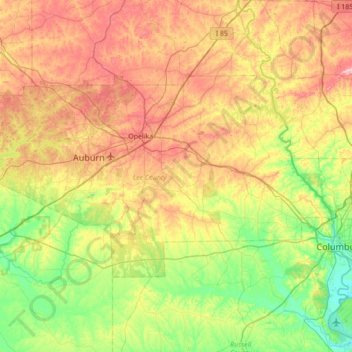
Name: Lee County topographic map, elevation, terrain.

Location: Lee County, Alabama, United States (32.40977 -85.69668 32.74651 -85.00100)

Average elevation: 168 m

Minimum elevation: 58 m

Maximum elevation: 337 m

Other topographic maps

Click on a map to view its topography, its elevation and its terrain.

Franklin County

United States > Alabama

Average elevation: 222 m

Alabaster

United States > Alabama > Shelby County

Average elevation: 173 m

Spruce Pine

United States > Alabama > Franklin County

Average elevation: 304 m

Mentone

United States > Alabama > DeKalb County

Mentone is located in eastern DeKalb County at 34°34′20″N 85°34′49″W / 34.57222°N 85.58028°W / 34.57222; -85.58028 (34.572360, -85.580283). It is bordered to the west by the town of Valley Head. The center of town is located on the crest of Lookout Mountain at an elevation of 1,736 feet…

Average elevation: 471 m

Goodway

United States > Alabama > Monroe County

Average elevation: 112 m

Russell County

United States > Alabama

Average elevation: 108 m

Rogersville

United States > Alabama > Lauderdale County

Average elevation: 197 m

Newville

United States > Alabama > Henry County

Average elevation: 114 m

Huntsville

United States > Alabama > Madison County

Average elevation: 230 m

Pickens County

United States > Alabama

Less than one-third of the county was developed for cotton plantations, which were worked by enslaved African-Americans brought south by northern businessmen interested in cheap cotton. These plantations were developed primarily in the southernmost reaches of the county, in the lowlands along the banks of the…

Average elevation: 78 m

Sheppard

United States > Alabama > Wilcox County

Average elevation: 21 m

Autauga County

United States > Alabama

Average elevation: 99 m

Fishing Lake

United States > Alabama > Clarke County

Average elevation: 4 m

Union Springs

United States > Alabama > Bullock County

Average elevation: 139 m

Masseyline

United States > Alabama > Jefferson County

Average elevation: 173 m

Notasulga

United States > Alabama > Macon County

Average elevation: 149 m

Limestone County

United States > Alabama

Average elevation: 209 m

Jones Lake

United States > Alabama > Lee County > Auburn

Average elevation: 187 m

Dale County

United States > Alabama

Average elevation: 96 m

Stevenson

United States > Alabama > Jackson County

Average elevation: 247 m

Scottland

United States > Alabama > Bullock County

Average elevation: 150 m

Daphne

United States > Alabama > Baldwin County

The topography of Daphne is quite consistent from a gently sloping sea level on the west to low rolling hills further east. Generally, the entire city lies no more than 150 feet above sea level. The land along the Daphne bay coast, like other land throughout the county, is rich with sandy-loam type soils.

Average elevation: 25 m

Tabernacle

United States > Alabama > Coffee County

Average elevation: 119 m

Bessemer

United States > Alabama > Jefferson County

Average elevation: 175 m

Fairhope

United States > Alabama > Baldwin County

According to the U.S. Census Bureau, the city has a total area of 12.0 square miles (31.1 km2), of which 0.019 square mile (0.05 km2), or 0.16%, is water. Its elevation ranges from sea level at the bay to 122 feet (37 m) in the city center.

Average elevation: 17 m

Alabama River

United States > Alabama

Average elevation: 68 m

Flomaton

United States > Alabama > Escambia County

Average elevation: 42 m

Avon Park

United States > Alabama > Jefferson County > Birmingham

Average elevation: 189 m

Gulf Shores

United States > Alabama > Baldwin County

Average elevation: 4 m

Jefferson County

United States > Alabama

The county is located within the Ridge-and-Valley Appalachians, with the highest point in the county being found at Shades Mountain, at an elevation of 1,150 ft. Another significant mountain located within the county is Red Mountain, which runs to the south of downtown Birmingham and separates the city from…

Average elevation: 173 m

Monroe County

United States > Alabama

Average elevation: 76 m

Decatur

United States > Alabama > Morgan County

Average elevation: 186 m

Pine Ridge

United States > Alabama > DeKalb County

Average elevation: 312 m

Madison

United States > Alabama > Jefferson County > Brighton

Average elevation: 163 m

Martins

United States > Alabama > Jefferson County > Birmingham

Average elevation: 176 m

Auburn

United States > Alabama > Lee County

The southwest and west regions of the city on the plateau are marked by rolling plains and savannahs, with the undeveloped portion primarily being used for cattle grazing and ranching. South of this region sits the coastal plain, with sandy soil and pine forest. Parts of north Auburn have much more rugged…

Average elevation: 200 m

Simpson

United States > Alabama > Tallapoosa County

Average elevation: 237 m