Geolocate

Theodore topographic map

Click on the map to display elevation.

About this map

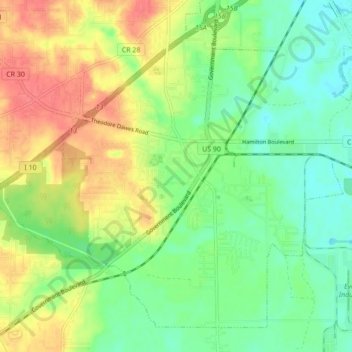
Name: Theodore topographic map, elevation, terrain.

Location: Theodore, Mobile County, Alabama, 36582, United States (30.51530 -88.22574 30.57928 -88.13908)

Average elevation: 24 m

Minimum elevation: 0 m

Maximum elevation: 57 m

Gear up for your next adventure:

Lightweight Backpacking Tent - Compact tent for efficient hiking trips
🕶️Polarized Sunglasses - Reduces glare from snow and water at high elevations
🔭Compact Binoculars - Lightweight optics for scouting trails and wildlife
🛰️Satellite Messenger - Emergency communication for areas with no cell service
🥾Mountain Trail Shoes - High-traction shoes for mountain trails

As an Amazon Associate, this site earns from qualifying purchases at no extra cost to you.