
Kerrobert topographic map
Click on the map to display elevation.
About this map
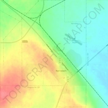
Name: Kerrobert topographic map, elevation, terrain.
Location: Kerrobert, Saskatchewan, S0L 1R0, Canada (51.90310 -109.15835 51.93999 -109.12260)
Average elevation: 682 m
Minimum elevation: 653 m
Maximum elevation: 718 m
Saskatchewan trails, hiking, mountain biking, running and outdoor activities
Other topographic maps
Click on a map to view its topography, its elevation and its terrain.
Turnor Lake
Canada > Saskatchewan > Northern Saskatchewan Administration District > Turnor Lake
Average elevation: 426 m
McClean Lake
Canada > Saskatchewan > Division No. 18 > Unorganized Division No. 18
Average elevation: 440 m
La Loche
Canada > Saskatchewan > Northern Saskatchewan Administration District > La Loche
Average elevation: 447 m
Pelican Narrows
Canada > Saskatchewan > Northern Saskatchewan Administration District > Pelican Narrows
Average elevation: 321 m