
Presidio County topographic map
Interactive map
Click on the map to display elevation.
About this map
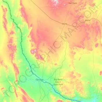
Name: Presidio County topographic map, elevation, terrain.
Location: Presidio County, Texas, United States (29.25837 -104.98075 30.62922 -103.79246)
Average elevation: 1,255 m
Minimum elevation: 716 m
Maximum elevation: 2,348 m
Geographically, Presidio County comprises 3,857 square miles (9,990 km2) of contrasting topography, geology, and vegetation. In the north and west, clay and sandy loam cover the rolling plains known as the Marfa Plateau and the Highland Country, providing good ranges of grama grasses for the widely acclaimed Highland Herefords. In the central, far western, and southeastern areas of the county, some of the highest mountain ranges in Texas are found. These peaks are formed of volcanic rock and covered with loose surface rubble. They support desert shrubs and cacti and dominate a landscape of rugged canyons and numerous springs. The spring-fed Capote Falls, with a drop of 175 feet (53 m), the highest in Texas, is located in western Presidio County. In the southern and western parts of the county, the volcanic cliffs of the Candelaria Rimrock (also called the Sierra Vieja) rise perpendicular and run parallel to the river, separating the highland prairies from the desert floor hundreds of feet below them. The gravel pediment, which allows only the growth of desert shrubs and cacti, extends from the Rimrock to the flood plain of the river. Along the river, irrigation allows the farming of vegetables, grains, and cotton. No permanent streams exist in the county, although many arroyos become raging torrents during heavy rainfalls. Major ones are Alamito Creek, Cibolo Creek, Capote Creek, and Pinto Canyon. San Esteban Dam was built across Alamito Creek and on the site of a historic spring-fed tinaja in 1911 as an irrigation and land-promotion project. Altitudes in the county vary from 2,518 to 7,728 feet (767 to 2,355 m) above sea level. Temperatures, moderated by the mountains, vary from 33 °F (1 °C) in January to 100 °F (38 °C) in July. Average rainfall is 12 inches (300 mm) per year, mainly in June, July, and August. The growing season extends for 238 days. Natural resources under production in 1982 were perlite, crushed rhyolite, sand, and gravel. Silver mining contributed greatly to the economy of the county from the 1880s to the 1940s. Presidio County has no oil or gas production.
Other topographic maps
Click on a map to view its topography, its elevation and its terrain.
Flower Mound
United States > Texas > Denton County
Flower Mound, Denton County, Texas, United States
Average elevation: 178 m
Galveston
United States > Texas > Galveston County
Galveston, Galveston County, Texas, United States
Average elevation: 1 m
USA
United States > Texas > Tarrant County > Arlington
USA, Arlington, Tarrant County, Texas, 76011, United States
Average elevation: 170 m
Lubbock
United States > Texas > Lubbock County
Lubbock, Lubbock County, Texas, United States
Average elevation: 983 m
Leander
United States > Texas > Williamson County > Leander
Leander, Williamson County, Texas, 78641, United States
Average elevation: 297 m
Temple
United States > Texas > Bell County
Temple, Bell County, Texas, United States
Average elevation: 186 m
Woodville
United States > Texas > Tyler County
Woodville, Tyler County, Texas, United States
Average elevation: 84 m
Kingsville
United States > Texas > Kleberg County
Kingsville, Kleberg County, Texas, 78363, United States
Average elevation: 19 m
Grandview
United States > Texas > Johnson County
Grandview, Johnson County, Texas, United States
Average elevation: 206 m
Saginaw
United States > Texas > Tarrant County
Saginaw, Tarrant County, Texas, United States
Average elevation: 216 m
Orchard
United States > Texas > Fort Bend County
Orchard, Fort Bend County, Texas, 77464, United States
Average elevation: 38 m
Waco
United States > Texas > McLennan County
Waco, McLennan County, Texas, United States
Average elevation: 147 m
Bellaire
United States > Texas > Harris County
Bellaire, Harris County, Texas, United States
Average elevation: 20 m
Childress County
Childress County, Texas, 79201, United States
Average elevation: 546 m
Boomtown
United States > Texas > Tarrant County > Arlington
Boomtown, Arlington, Tarrant County, Texas, 76006, United States
Average elevation: 170 m
Midway
United States > Texas > Madison County
Midway, Madison County, Texas, United States
Average elevation: 76 m
Vanderpool
United States > Texas > Bandera County
Vanderpool, Bandera County, Texas, 78885, United States
Average elevation: 524 m
Millsap
United States > Texas > Parker County
Millsap, Parker County, Texas, United States
Average elevation: 257 m
Sugar Land
United States > Texas > Fort Bend County
Sugar Land, Fort Bend County, Texas, United States
Average elevation: 24 m
Baytown
United States > Texas > Harris County
Baytown, Harris County, Texas, United States
Average elevation: 7 m
Tobacco Patch
United States > Texas > Polk County
Tobacco Patch, Polk County, Texas, United States
Average elevation: 43 m
San Leon
United States > Texas > Galveston County
San Leon, Galveston County, Texas, 77395, United States
Average elevation: 1 m
Enchanted Rock
United States > Texas > Llano County
Enchanted Rock, Llano County, Texas, United States
Average elevation: 453 m
Leon Valley
United States > Texas > Bexar County
Leon Valley, Bexar County, Texas, United States
Average elevation: 260 m
Hitchcock
United States > Texas > Galveston County
Hitchcock, Galveston County, Texas, 77563, United States
Average elevation: 3 m
Kerrville
United States > Texas > Kerr County
Kerrville, Kerr County, Texas, United States
Average elevation: 545 m
Big Spring
United States > Texas > Howard County
Big Spring, Howard County, Texas, 79720, United States
Average elevation: 781 m
Allen
United States > Texas > Collin County
Allen, Collin County, Texas, United States
Average elevation: 200 m
Mission
United States > Texas > Hidalgo County
Mission, Hidalgo County, Texas, United States
Average elevation: 39 m
Tuck Lake
United States > Texas > Bastrop County > Camp Swift
Tuck Lake, Camp Swift, Bastrop County, Texas, United States
Average elevation: 139 m
El Paso
United States > Texas > El Paso County
El Paso, El Paso County, Texas, United States
Average elevation: 1,237 m
Edinburg
United States > Texas > Hidalgo County > Edinburg
Edinburg, Hidalgo County, Texas, United States
Average elevation: 32 m
North Richland Hills
United States > Texas > Tarrant County
North Richland Hills, Tarrant County, Texas, United States
Average elevation: 191 m
Matagorda County
United States > Texas > Matagorda County
Matagorda County, Texas, United States
Average elevation: 8 m
Muenster
United States > Texas > Cooke County
Muenster, Cooke County, Texas, 76252, United States
Average elevation: 315 m
Big Foot Colonia
United States > Texas > Frio County
Big Foot Colonia, Frio County, Texas, 78005, United States
Average elevation: 197 m
Junction
United States > Texas > Kimble County
Junction, Kimble County, Texas, 76849, United States
Average elevation: 532 m
Baxter Island
United States > Texas > Matagorda County
Baxter Island, Matagorda County, Texas, 77415, United States
Average elevation: 4 m
Clyde
United States > Texas > Callahan County
Clyde, Callahan County, Texas, United States
Average elevation: 610 m
La Porte
United States > Texas > Harris County
La Porte, Harris County, Texas, 77571, United States
Average elevation: 4 m
Westbrook
United States > Texas > Mitchell County
Westbrook, Mitchell County, Texas, 79565, United States
Average elevation: 657 m
Furguson
United States > Texas > Hale County
Furguson, Hale County, Texas, United States
Average elevation: 1,032 m
Laredo
United States > Texas > Webb County
Laredo, Webb County, Texas, United States
Average elevation: 160 m
Little Elm
United States > Texas > Denton County
Little Elm, Denton County, Texas, 75068, United States
Average elevation: 171 m