Geolocate

Vanderpool topographic map

Click on the map to display elevation.

About this map

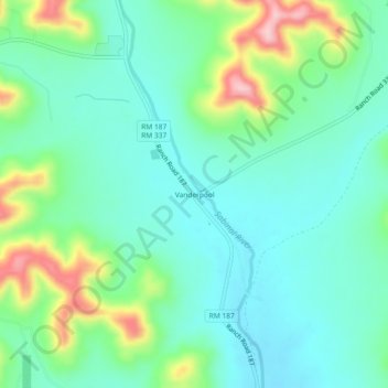
Name: Vanderpool topographic map, elevation, terrain.

Location: Vanderpool, Bandera County, Texas, 78885, United States (29.72403 -99.57473 29.76403 -99.53473)

Average elevation: 524 m

Minimum elevation: 473 m

Maximum elevation: 662 m

Gear up for your next adventure:

🧴Outdoor Sunscreen - High SPF protection for high-altitude UV exposure
📷Outdoor Action Camera - Capture high-elevation views and rugged adventures
🔦LED Headtorch - Bright and durable light for night activities
🥤Collapsible Travel Cup - Saves space and weight in your mess kit
🦶Anti-Blister Balm - Prevents friction and hotspots during long ascents

As an Amazon Associate, this site earns from qualifying purchases at no extra cost to you.