Geolocate

Hitchcock topographic map

Click on the map to display elevation.

About this map

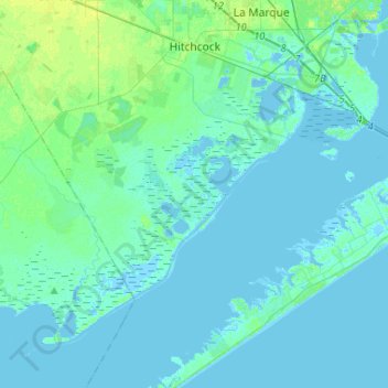
Name: Hitchcock topographic map, elevation, terrain.

Location: Hitchcock, Galveston County, Texas, 77563, United States (29.14771 -95.14504 29.37519 -94.90576)

Average elevation: 3 m

Minimum elevation: -9 m

Maximum elevation: 12 m

Other topographic maps

Click on a map to view its topography, its elevation and its terrain.

San Leon

United States > Texas > Galveston County

Average elevation: 1 m

Galveston

United States > Texas > Galveston County > Galveston

On September 8, 1900, the island was struck by a devastating hurricane. This event holds the record as the United States' deadliest natural disaster. The city was devastated, and an estimated 6,000 to 8,000 people on the island were killed. Following the storm, a 10-mile (16 km) long, 17 foot (5.2 m) high…

Average elevation: 1 m

Gear up for your next adventure:

🧥Thermal Fleece Jacket - Versatile insulation for changing mountain temperatures
🥾Waterproof Hiking Boots - Boots keeping your feet dry in wet conditions
🎒Backpack Rain Cover - External shield to keep your entire pack dry
🥾Approach Shoes - Shoes designed for climbing approaches and rugged trails
🥾Hiking Shorts - Breathable shorts suitable for summer hikes

As an Amazon Associate, this site earns from qualifying purchases at no extra cost to you.